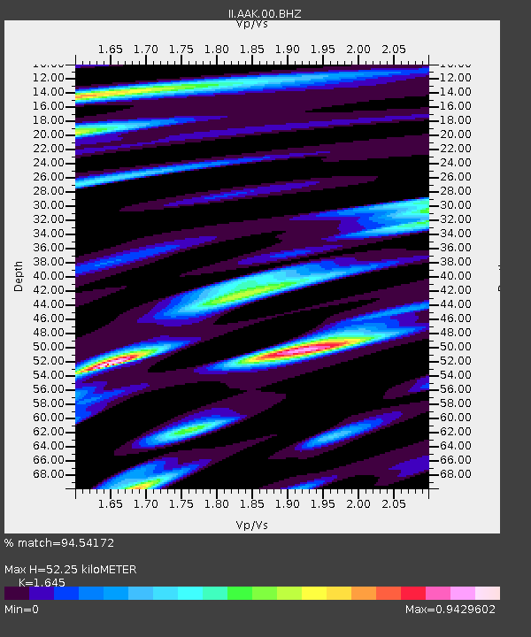
AAK Ala Archa, Kyrgyzstan - Earthquake Result Viewer

Earthquake location: Off East Coast Of Honshu, Japan
Earthquake latitude/longitude: 37.2/144.7
Earthquake time(UTC): 2013/10/25 (298) 17:10:19 GMT
Earthquake Depth: 35 km
Earthquake Magnitude: 7.1 MWW, 7.1 MWW, 7.1 MWB, 7.1 MWC, 7.2 MWC, 7.5 MI
Earthquake Catalog/Contributor: NEIC PDE/NEIC COMCAT
Network: II Global Seismograph Network (GSN - IRIS/IDA)
Station: AAK Ala Archa, Kyrgyzstan
Lat/Lon: 42.64 N/74.49 E
Elevation: 1645 m
Distance: 52.7 deg
Az: 299.245 deg
Baz: 70.86 deg
Ray Param: 0.06652211
Estimated Moho Depth: 52.25 km
Estimated Crust Vp/Vs: 1.64
Assumed Crust Vp: 6.306 km/s
Estimated Crust Vs: 3.833 km/s
Estimated Crust Poisson's Ratio: 0.21
Radial Match: 94.54172 %
Radial Bump: 400
Transverse Match: 89.16053 %
Transverse Bump: 400
SOD ConfigId: 626651
Insert Time: 2014-04-19 05:50:20.209 +0000
GWidth: 2.5
Max Bumps: 400
Tol: 0.001

Signal To Noise

ChannelStoNSTALTA
II:AAK:00:BHZ:20131025T17:19:00.218972Z51.244694.58879E-68.9546646E-8
II:AAK:00:BH1:20131025T17:19:00.218972Z20.597541.5544729E-67.546886E-8
II:AAK:00:BH2:20131025T17:19:00.218972Z34.8303641.9431802E-65.5789833E-8
Arrivals
Ps5.7 SECOND
PpPs21 SECOND
PsPs/PpSs26 SECOND