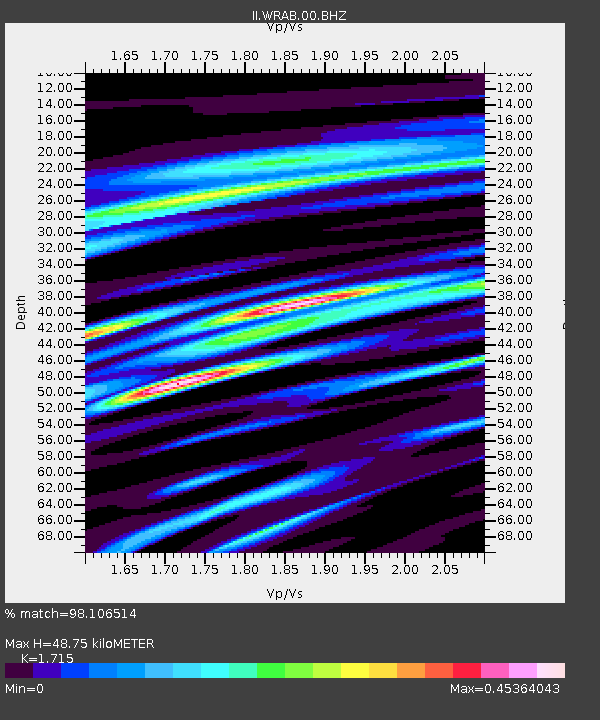
WRAB Tennant Creek, NT, Australia - Earthquake Result Viewer
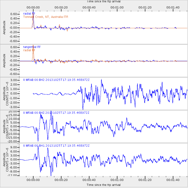
Earthquake location: Off East Coast Of Honshu, Japan
Earthquake latitude/longitude: 37.2/144.7
Earthquake time(UTC): 2013/10/25 (298) 17:10:19 GMT
Earthquake Depth: 35 km
Earthquake Magnitude: 7.1 MWW, 7.1 MWW, 7.1 MWB, 7.1 MWC, 7.2 MWC, 7.5 MI
Earthquake Catalog/Contributor: NEIC PDE/NEIC COMCAT
Network: II Global Seismograph Network (GSN - IRIS/IDA)
Station: WRAB Tennant Creek, NT, Australia
Lat/Lon: 19.93 S/134.36 E
Elevation: 366 m
Distance: 57.6 deg
Az: 191.493 deg
Baz: 9.741 deg
Ray Param: 0.0633211
Estimated Moho Depth: 48.75 km
Estimated Crust Vp/Vs: 1.72
Assumed Crust Vp: 6.642 km/s
Estimated Crust Vs: 3.873 km/s
Estimated Crust Poisson's Ratio: 0.24
Radial Match: 98.106514 %
Radial Bump: 297
Transverse Match: 89.494995 %
Transverse Bump: 400
SOD ConfigId: 626651
Insert Time: 2014-04-19 05:50:55.122 +0000
GWidth: 2.5
Max Bumps: 400
Tol: 0.001

Signal To Noise

ChannelStoNSTALTA
II:WRAB:00:BHZ:20131025T17:19:35.468972Z30.8360126.928949E-62.2470314E-7
II:WRAB:00:BH1:20131025T17:19:35.468972Z21.8164313.687123E-61.6900671E-7
II:WRAB:00:BH2:20131025T17:19:35.468972Z4.84596066.4008606E-71.3208653E-7
Arrivals
Ps5.5 SECOND
PpPs19 SECOND
PsPs/PpSs24 SECOND