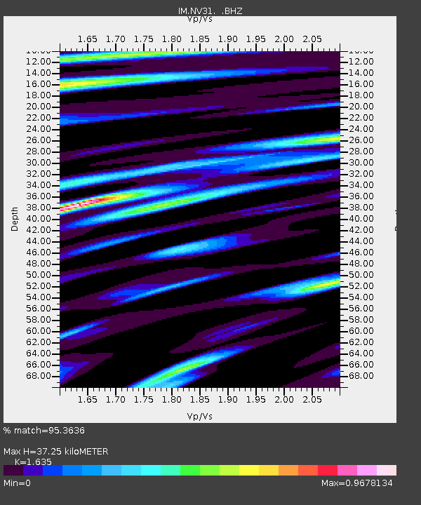
NV31 NVAR Array Site 31, Mina, NV, USA - Earthquake Result Viewer

Earthquake location: Off East Coast Of Honshu, Japan
Earthquake latitude/longitude: 37.2/144.7
Earthquake time(UTC): 2013/10/25 (298) 17:10:19 GMT
Earthquake Depth: 35 km
Earthquake Magnitude: 7.1 MWW, 7.1 MWW, 7.1 MWB, 7.1 MWC, 7.2 MWC, 7.5 MI
Earthquake Catalog/Contributor: NEIC PDE/NEIC COMCAT
Network: IM International Miscellaneous Stations
Station: NV31 NVAR Array Site 31, Mina, NV, USA
Lat/Lon: 38.43 N/118.16 W
Elevation: 1509 m
Distance: 72.9 deg
Az: 54.606 deg
Baz: 303.975 deg
Ray Param: 0.053296674
Estimated Moho Depth: 37.25 km
Estimated Crust Vp/Vs: 1.63
Assumed Crust Vp: 6.279 km/s
Estimated Crust Vs: 3.84 km/s
Estimated Crust Poisson's Ratio: 0.20
Radial Match: 95.3636 %
Radial Bump: 400
Transverse Match: 92.695076 %
Transverse Bump: 400
SOD ConfigId: 626651
Insert Time: 2014-04-19 05:51:02.784 +0000
GWidth: 2.5
Max Bumps: 400
Tol: 0.001

Signal To Noise

ChannelStoNSTALTA
IM:NV31: :BHZ:20131025T17:21:14.399026Z51.0049864.73846E-69.29019E-8
IM:NV31: :BHN:20131025T17:21:14.399026Z9.23179151.2270822E-61.3291918E-7
IM:NV31: :BHE:20131025T17:21:14.399026Z7.8773371.1253494E-61.4285912E-7
Arrivals
Ps3.9 SECOND
PpPs15 SECOND
PsPs/PpSs19 SECOND