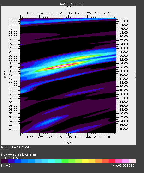
CTAO Charters Towers, Australia - Earthquake Result Viewer
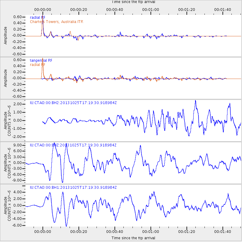
Earthquake location: Off East Coast Of Honshu, Japan
Earthquake latitude/longitude: 37.2/144.7
Earthquake time(UTC): 2013/10/25 (298) 17:10:19 GMT
Earthquake Depth: 35 km
Earthquake Magnitude: 7.1 MWW, 7.1 MWW, 7.1 MWB, 7.1 MWC, 7.2 MWC, 7.5 MI
Earthquake Catalog/Contributor: NEIC PDE/NEIC COMCAT
Network: IU Global Seismograph Network (GSN - IRIS/USGS)
Station: CTAO Charters Towers, Australia
Lat/Lon: 20.09 S/146.25 E
Elevation: 357 m
Distance: 57.0 deg
Az: 178.213 deg
Baz: 358.481 deg
Ray Param: 0.06373868
Estimated Moho Depth: 35.25 km
Estimated Crust Vp/Vs: 1.81
Assumed Crust Vp: 6.522 km/s
Estimated Crust Vs: 3.603 km/s
Estimated Crust Poisson's Ratio: 0.28
Radial Match: 97.01094 %
Radial Bump: 239
Transverse Match: 79.590225 %
Transverse Bump: 400
SOD ConfigId: 626651
Insert Time: 2014-04-19 05:51:36.464 +0000
GWidth: 2.5
Max Bumps: 400
Tol: 0.001

Signal To Noise

ChannelStoNSTALTA
IU:CTAO:00:BHZ:20131025T17:19:30.918984Z17.3739174.3509317E-62.5042894E-7
IU:CTAO:00:BH1:20131025T17:19:30.918984Z11.2203522.271619E-62.0245523E-7
IU:CTAO:00:BH2:20131025T17:19:30.918984Z0.93250981.7110891E-71.8349287E-7
Arrivals
Ps4.6 SECOND
PpPs14 SECOND
PsPs/PpSs19 SECOND