KONO Kongsberg, Norway - Earthquake Result Viewer
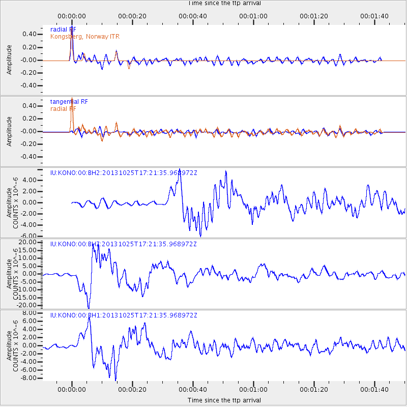
Earthquake location: Off East Coast Of Honshu, Japan
Earthquake latitude/longitude: 37.2/144.7
Earthquake time(UTC): 2013/10/25 (298) 17:10:19 GMT
Earthquake Depth: 35 km
Earthquake Magnitude: 7.1 MWW, 7.1 MWW, 7.1 MWB, 7.1 MWC, 7.2 MWC, 7.5 MI
Earthquake Catalog/Contributor: NEIC PDE/NEIC COMCAT
Network: IU Global Seismograph Network (GSN - IRIS/USGS)
Station: KONO Kongsberg, Norway
Lat/Lon: 59.65 N/9.60 E
Elevation: 216 m
Distance: 76.7 deg
Az: 338.368 deg
Baz: 35.45 deg
Ray Param: 0.0508005
Estimated Moho Depth: 17.75 km
Estimated Crust Vp/Vs: 1.89
Assumed Crust Vp: 6.545 km/s
Estimated Crust Vs: 3.459 km/s
Estimated Crust Poisson's Ratio: 0.31
Radial Match: 94.721794 %
Radial Bump: 400
Transverse Match: 82.227615 %
Transverse Bump: 400
SOD ConfigId: 626651
Insert Time: 2014-04-19 05:51:53.318 +0000
GWidth: 2.5
Max Bumps: 400
Tol: 0.001

Signal To Noise

ChannelStoNSTALTA
IU:KONO:00:BHZ:20131025T17:21:35.968972Z12.3107356.649635E-65.4014936E-7
IU:KONO:00:BH1:20131025T17:21:35.968972Z4.7111452.062968E-64.37891E-7
IU:KONO:00:BH2:20131025T17:21:35.968972Z4.568921.8265515E-63.9977752E-7
Arrivals
Ps2.5 SECOND
PpPs7.6 SECOND
PsPs/PpSs10 SECOND