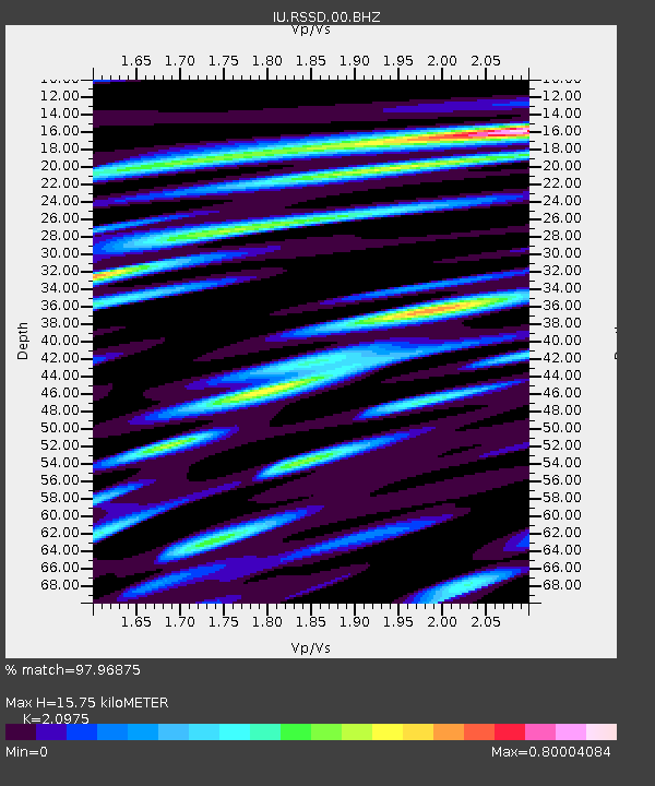
RSSD Black Hills, South Dakota, USA - Earthquake Result Viewer
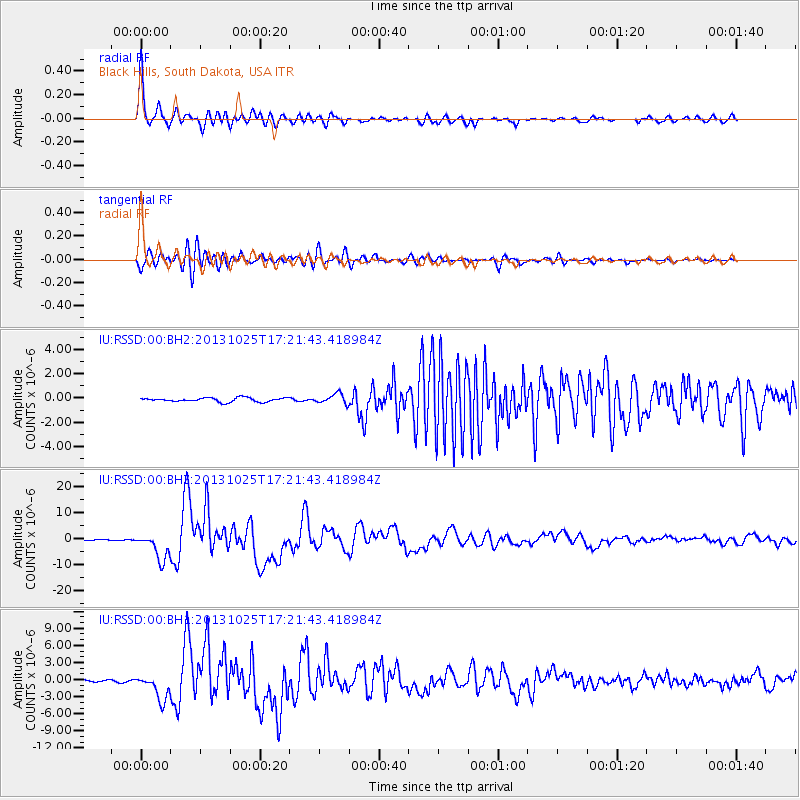
Earthquake location: Off East Coast Of Honshu, Japan
Earthquake latitude/longitude: 37.2/144.7
Earthquake time(UTC): 2013/10/25 (298) 17:10:19 GMT
Earthquake Depth: 35 km
Earthquake Magnitude: 7.1 MWW, 7.1 MWW, 7.1 MWB, 7.1 MWC, 7.2 MWC, 7.5 MI
Earthquake Catalog/Contributor: NEIC PDE/NEIC COMCAT
Network: IU Global Seismograph Network (GSN - IRIS/USGS)
Station: RSSD Black Hills, South Dakota, USA
Lat/Lon: 44.12 N/104.04 W
Elevation: 2090 m
Distance: 78.0 deg
Az: 43.316 deg
Baz: 310.445 deg
Ray Param: 0.04990059
Estimated Moho Depth: 15.75 km
Estimated Crust Vp/Vs: 2.10
Assumed Crust Vp: 6.242 km/s
Estimated Crust Vs: 2.976 km/s
Estimated Crust Poisson's Ratio: 0.35
Radial Match: 97.96875 %
Radial Bump: 400
Transverse Match: 92.9849 %
Transverse Bump: 400
SOD ConfigId: 626651
Insert Time: 2014-04-19 05:52:09.282 +0000
GWidth: 2.5
Max Bumps: 400
Tol: 0.001

Signal To Noise

ChannelStoNSTALTA
IU:RSSD:00:BHZ:20131025T17:21:43.418984Z27.2388135.1979814E-61.9082995E-7
IU:RSSD:00:BH1:20131025T17:21:43.418984Z8.4603272.2501088E-62.6596004E-7
IU:RSSD:00:BH2:20131025T17:21:43.418984Z2.43422874.0208073E-71.6517788E-7
Arrivals
Ps2.8 SECOND
PpPs7.6 SECOND
PsPs/PpSs10 SECOND