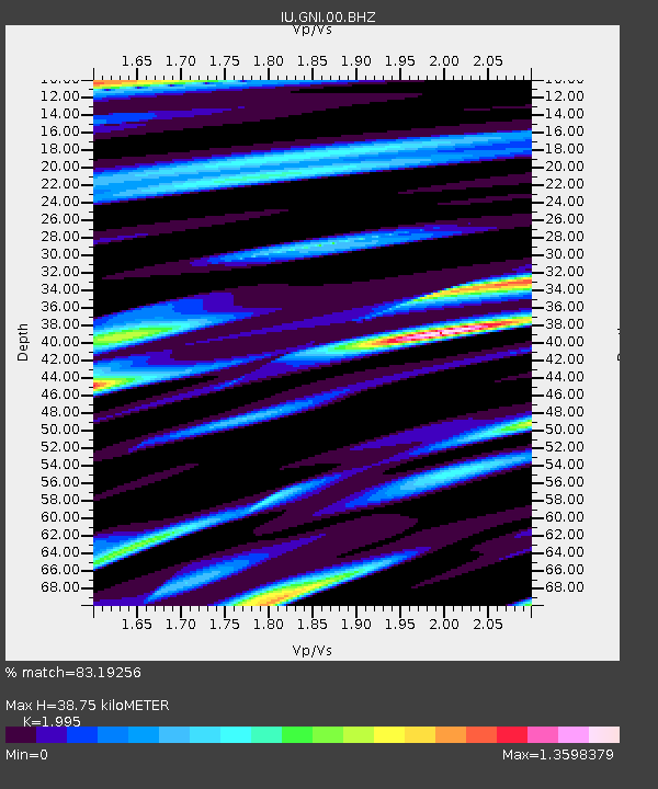
GNI Garni, Armenia - Earthquake Result Viewer
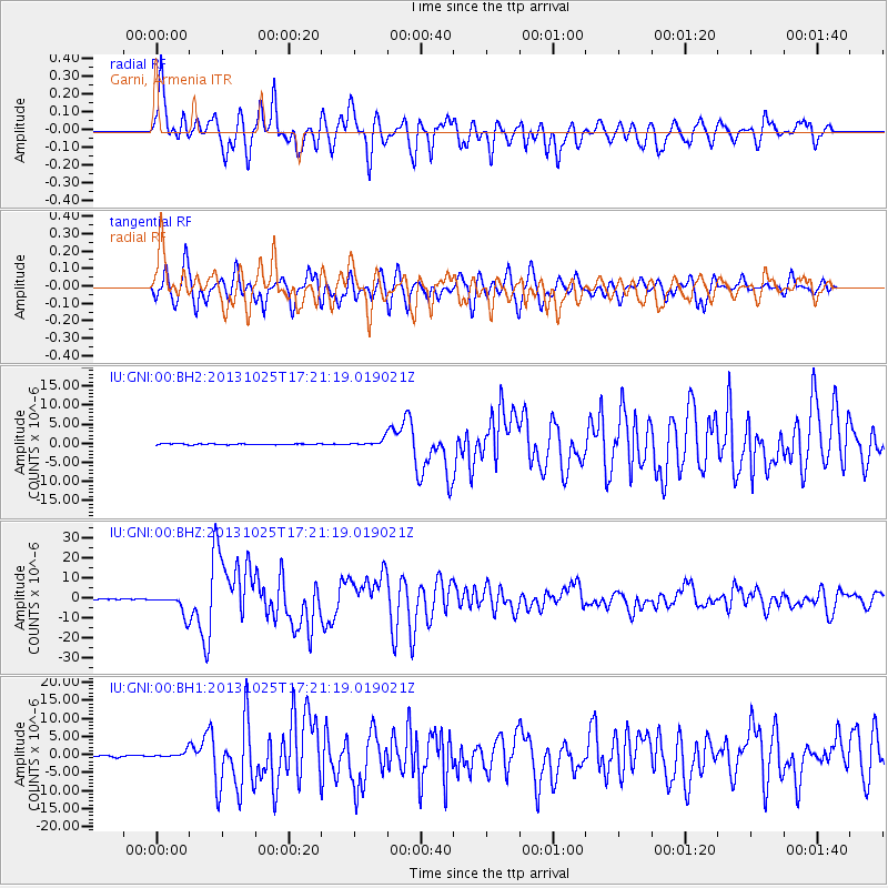
Earthquake location: Off East Coast Of Honshu, Japan
Earthquake latitude/longitude: 37.2/144.7
Earthquake time(UTC): 2013/10/25 (298) 17:10:19 GMT
Earthquake Depth: 35 km
Earthquake Magnitude: 7.1 MWW, 7.1 MWW, 7.1 MWB, 7.1 MWC, 7.2 MWC, 7.5 MI
Earthquake Catalog/Contributor: NEIC PDE/NEIC COMCAT
Network: IU Global Seismograph Network (GSN - IRIS/USGS)
Station: GNI Garni, Armenia
Lat/Lon: 40.15 N/44.74 E
Elevation: 1609 m
Distance: 73.7 deg
Az: 308.123 deg
Baz: 55.082 deg
Ray Param: 0.052779667
Estimated Moho Depth: 38.75 km
Estimated Crust Vp/Vs: 2.00
Assumed Crust Vp: 6.291 km/s
Estimated Crust Vs: 3.153 km/s
Estimated Crust Poisson's Ratio: 0.33
Radial Match: 83.19256 %
Radial Bump: 400
Transverse Match: 75.02227 %
Transverse Bump: 400
SOD ConfigId: 626651
Insert Time: 2014-04-19 05:52:25.092 +0000
GWidth: 2.5
Max Bumps: 400
Tol: 0.001

Signal To Noise

ChannelStoNSTALTA
IU:GNI:00:BHZ:20131025T17:21:19.019021Z30.6971115.247833E-61.7095529E-7
IU:GNI:00:BH1:20131025T17:21:19.019021Z4.61000358.9701103E-71.9457926E-7
IU:GNI:00:BH2:20131025T17:21:19.019021Z6.28929478.2189274E-71.3068123E-7
Arrivals
Ps6.3 SECOND
PpPs18 SECOND
PsPs/PpSs24 SECOND