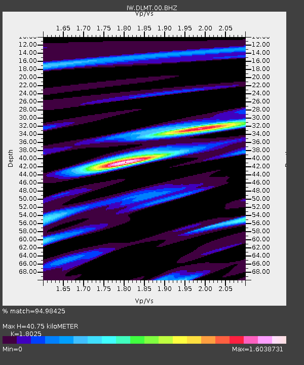
DLMT Dillon, Montana, USA - Earthquake Result Viewer

Earthquake location: Off East Coast Of Honshu, Japan
Earthquake latitude/longitude: 37.2/144.7
Earthquake time(UTC): 2013/10/25 (298) 17:10:19 GMT
Earthquake Depth: 35 km
Earthquake Magnitude: 7.1 MWW, 7.1 MWW, 7.1 MWB, 7.1 MWC, 7.2 MWC, 7.5 MI
Earthquake Catalog/Contributor: NEIC PDE/NEIC COMCAT
Network: IW Intermountain West
Station: DLMT Dillon, Montana, USA
Lat/Lon: 45.36 N/112.60 W
Elevation: 1569 m
Distance: 72.4 deg
Az: 46.169 deg
Baz: 305.164 deg
Ray Param: 0.05362879
Estimated Moho Depth: 40.75 km
Estimated Crust Vp/Vs: 1.80
Assumed Crust Vp: 6.577 km/s
Estimated Crust Vs: 3.649 km/s
Estimated Crust Poisson's Ratio: 0.28
Radial Match: 94.98425 %
Radial Bump: 400
Transverse Match: 87.69505 %
Transverse Bump: 400
SOD ConfigId: 626651
Insert Time: 2014-04-19 05:52:36.628 +0000
GWidth: 2.5
Max Bumps: 400
Tol: 0.001

Signal To Noise

ChannelStoNSTALTA
IW:DLMT:00:BHZ:20131025T17:21:11.394021Z30.0767773.3218153E-61.10444525E-7
IW:DLMT:00:BH1:20131025T17:21:11.394021Z3.2565168.7458517E-72.685647E-7
IW:DLMT:00:BH2:20131025T17:21:11.394021Z9.6559241.5088531E-61.562619E-7
Arrivals
Ps5.2 SECOND
PpPs17 SECOND
PsPs/PpSs22 SECOND