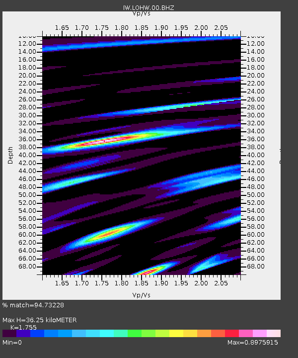
LOHW Long Hollow, Wyoming, USA - Earthquake Result Viewer

Earthquake location: Off East Coast Of Honshu, Japan
Earthquake latitude/longitude: 37.2/144.7
Earthquake time(UTC): 2013/10/25 (298) 17:10:19 GMT
Earthquake Depth: 35 km
Earthquake Magnitude: 7.1 MWW, 7.1 MWW, 7.1 MWB, 7.1 MWC, 7.2 MWC, 7.5 MI
Earthquake Catalog/Contributor: NEIC PDE/NEIC COMCAT
Network: IW Intermountain West
Station: LOHW Long Hollow, Wyoming, USA
Lat/Lon: 43.61 N/110.60 W
Elevation: 2121 m
Distance: 74.6 deg
Az: 46.773 deg
Baz: 306.727 deg
Ray Param: 0.052180964
Estimated Moho Depth: 36.25 km
Estimated Crust Vp/Vs: 1.75
Assumed Crust Vp: 6.207 km/s
Estimated Crust Vs: 3.537 km/s
Estimated Crust Poisson's Ratio: 0.26
Radial Match: 94.73228 %
Radial Bump: 400
Transverse Match: 91.91932 %
Transverse Bump: 400
SOD ConfigId: 626651
Insert Time: 2014-04-19 05:52:46.845 +0000
GWidth: 2.5
Max Bumps: 400
Tol: 0.001

Signal To Noise

ChannelStoNSTALTA
IW:LOHW:00:BHZ:20131025T17:21:24.163979Z28.4933473.3639171E-61.1805974E-7
IW:LOHW:00:BH1:20131025T17:21:24.163979Z3.92011337.419268E-71.8926157E-7
IW:LOHW:00:BH2:20131025T17:21:24.163979Z4.97439439.702067E-71.9504016E-7
Arrivals
Ps4.5 SECOND
PpPs16 SECOND
PsPs/PpSs20 SECOND