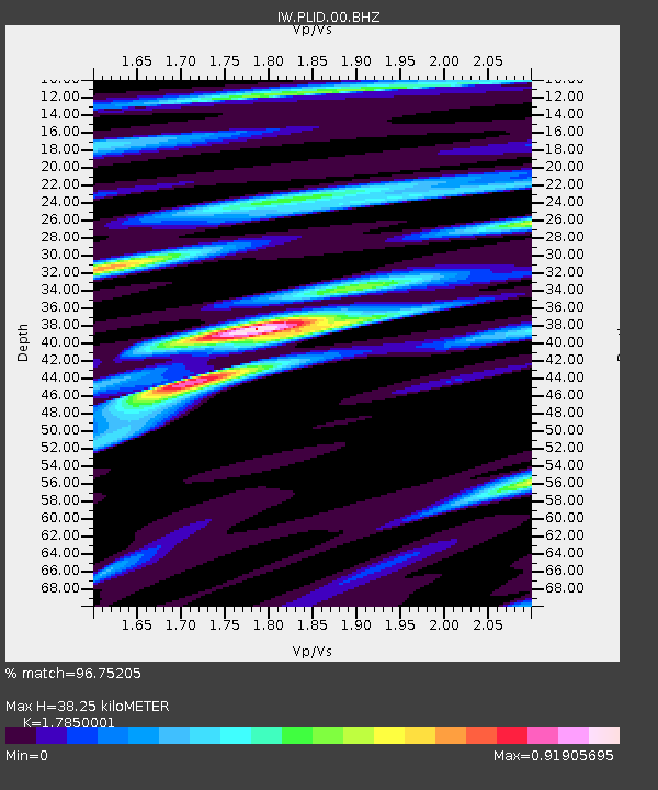
PLID Pearl Lake, Idaho, USA - Earthquake Result Viewer
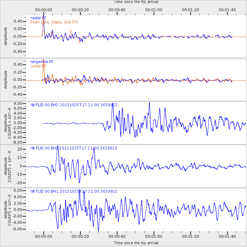
Earthquake location: Off East Coast Of Honshu, Japan
Earthquake latitude/longitude: 37.2/144.7
Earthquake time(UTC): 2013/10/25 (298) 17:10:19 GMT
Earthquake Depth: 35 km
Earthquake Magnitude: 7.1 MWW, 7.1 MWW, 7.1 MWB, 7.1 MWC, 7.2 MWC, 7.5 MI
Earthquake Catalog/Contributor: NEIC PDE/NEIC COMCAT
Network: IW Intermountain West
Station: PLID Pearl Lake, Idaho, USA
Lat/Lon: 45.09 N/116.00 W
Elevation: 2164 m
Distance: 70.6 deg
Az: 47.835 deg
Baz: 303.284 deg
Ray Param: 0.05484027
Estimated Moho Depth: 38.25 km
Estimated Crust Vp/Vs: 1.79
Assumed Crust Vp: 6.571 km/s
Estimated Crust Vs: 3.681 km/s
Estimated Crust Poisson's Ratio: 0.27
Radial Match: 96.75205 %
Radial Bump: 400
Transverse Match: 92.15409 %
Transverse Bump: 400
SOD ConfigId: 626651
Insert Time: 2014-04-19 05:52:56.637 +0000
GWidth: 2.5
Max Bumps: 400
Tol: 0.001

Signal To Noise

ChannelStoNSTALTA
IW:PLID:00:BHZ:20131025T17:21:00.363992Z15.5603063.6014999E-62.3145432E-7
IW:PLID:00:BH1:20131025T17:21:00.363992Z9.1296378.6909034E-79.519441E-8
IW:PLID:00:BH2:20131025T17:21:00.363992Z8.2136311.1414272E-61.3896744E-7
Arrivals
Ps4.7 SECOND
PpPs16 SECOND
PsPs/PpSs20 SECOND