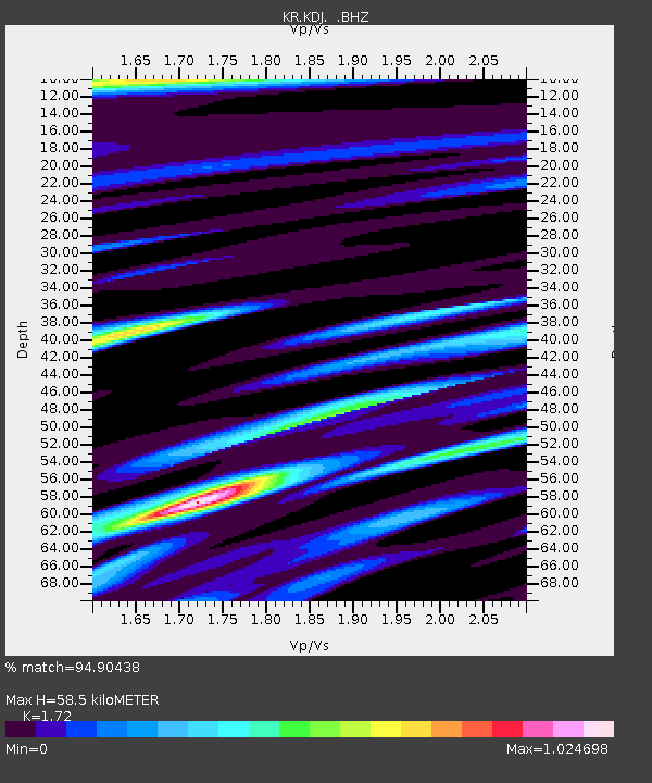
KDJ Kadji-Say, Kyrgyzstan - Earthquake Result Viewer

Earthquake location: Off East Coast Of Honshu, Japan
Earthquake latitude/longitude: 37.2/144.7
Earthquake time(UTC): 2013/10/25 (298) 17:10:19 GMT
Earthquake Depth: 35 km
Earthquake Magnitude: 7.1 MWW, 7.1 MWW, 7.1 MWB, 7.1 MWC, 7.2 MWC, 7.5 MI
Earthquake Catalog/Contributor: NEIC PDE/NEIC COMCAT
Network: KR Kyrgyz Digital Network
Station: KDJ Kadji-Say, Kyrgyzstan
Lat/Lon: 42.12 N/77.18 E
Elevation: 1830 m
Distance: 51.0 deg
Az: 297.81 deg
Baz: 71.778 deg
Ray Param: 0.067630805
Estimated Moho Depth: 58.5 km
Estimated Crust Vp/Vs: 1.72
Assumed Crust Vp: 6.306 km/s
Estimated Crust Vs: 3.666 km/s
Estimated Crust Poisson's Ratio: 0.24
Radial Match: 94.90438 %
Radial Bump: 400
Transverse Match: 91.22253 %
Transverse Bump: 400
SOD ConfigId: 626651
Insert Time: 2014-04-19 05:53:44.986 +0000
GWidth: 2.5
Max Bumps: 400
Tol: 0.001

Signal To Noise

ChannelStoNSTALTA
KR:KDJ: :BHZ:20131025T17:18:47.424996Z47.4697075.275129E-61.11126205E-7
KR:KDJ: :BHN:20131025T17:18:47.424996Z6.63270471.9889198E-62.9986558E-7
KR:KDJ: :BHE:20131025T17:18:47.424996Z19.6810071.9413767E-69.864214E-8
Arrivals
Ps7.1 SECOND
PpPs24 SECOND
PsPs/PpSs31 SECOND