You are here: Home > Network List > II - Global Seismograph Network (GSN - IRIS/IDA) Stations List
> Station TLY Talaya, Russia > Earthquake Result Viewer
TLY Talaya, Russia - Earthquake Result Viewer
| Earthquake location: |
Irian Jaya, Indonesia |
| Earthquake latitude/longitude: |
-3.7/140.3 |
| Earthquake time(UTC): |
1995/12/19 (353) 23:28:12 GMT |
| Earthquake Depth: |
71 km |
| Earthquake Magnitude: |
6.2 MB, 6.5 UNKNOWN |
| Earthquake Catalog/Contributor: |
WHDF/NEIC |
|
| Network: |
II Global Seismograph Network (GSN - IRIS/IDA) |
| Station: |
TLY Talaya, Russia |
| Lat/Lon: |
51.68 N/103.64 E |
| Elevation: |
579 m |
|
| Distance: |
63.3 deg |
| Az: |
335.444 deg |
| Baz: |
138.232 deg |
| Ray Param: |
0.059460722 |
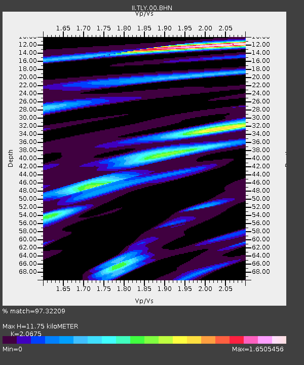
| Estimated Moho Depth: |
11.75 km |
| Estimated Crust Vp/Vs: |
2.07 |
| Assumed Crust Vp: |
6.419 km/s |
| Estimated Crust Vs: |
3.105 km/s |
| Estimated Crust Poisson's Ratio: |
0.35 |
|
| Radial Match: |
97.32209 % |
| Radial Bump: |
400 |
| Transverse Match: |
92.78476 % |
| Transverse Bump: |
400 |
| SOD ConfigId: |
61242 |
| Insert Time: |
2010-03-01 17:29:34.508 +0000 |
| GWidth: |
2.5 |
| Max Bumps: |
400 |
| Tol: |
0.001 |
|

Signal To Noise
| Channel | StoN | STA | LTA |
| II:TLY:00:BHN:19951219T23:38:03.776013Z | 16.893366 | 5.197433E-7 | 3.0766117E-8 |
| II:TLY:00:BHE:19951219T23:38:03.776013Z | 10.685765 | 4.196125E-7 | 3.926836E-8 |
| II:TLY:00:BHZ:19951219T23:38:03.776013Z | 29.892221 | 1.5249813E-6 | 5.101599E-8 |
| Arrivals |
| Ps | 2.0 SECOND |
| PpPs | 5.4 SECOND |
| PsPs/PpSs | 7.4 SECOND |


