You are here: Home > Network List > II - Global Seismograph Network (GSN - IRIS/IDA) Stations List
> Station TLY Talaya, Russia > Earthquake Result Viewer
TLY Talaya, Russia - Earthquake Result Viewer
| Earthquake location: |
Samar, Philippines |
| Earthquake latitude/longitude: |
12.1/125.9 |
| Earthquake time(UTC): |
1995/04/21 (111) 05:17:00 GMT |
| Earthquake Depth: |
23 km |
| Earthquake Magnitude: |
5.6 MB, 6.9 MS, 6.7 UNKNOWN, 6.7 MW |
| Earthquake Catalog/Contributor: |
WHDF/NEIC |
|
| Network: |
II Global Seismograph Network (GSN - IRIS/IDA) |
| Station: |
TLY Talaya, Russia |
| Lat/Lon: |
51.68 N/103.64 E |
| Elevation: |
579 m |
|
| Distance: |
43.4 deg |
| Az: |
339.876 deg |
| Baz: |
147.29 deg |
| Ray Param: |
0.07255514 |
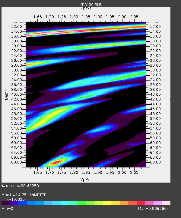
| Estimated Moho Depth: |
14.75 km |
| Estimated Crust Vp/Vs: |
1.66 |
| Assumed Crust Vp: |
6.419 km/s |
| Estimated Crust Vs: |
3.861 km/s |
| Estimated Crust Poisson's Ratio: |
0.22 |
|
| Radial Match: |
98.63253 % |
| Radial Bump: |
345 |
| Transverse Match: |
89.497185 % |
| Transverse Bump: |
400 |
| SOD ConfigId: |
6273 |
| Insert Time: |
2010-03-01 17:29:36.474 +0000 |
| GWidth: |
2.5 |
| Max Bumps: |
400 |
| Tol: |
0.001 |
|

Signal To Noise
| Channel | StoN | STA | LTA |
| II:TLY:00:BHN:19950421T05:24:30.603986Z | 2.9713516 | 1.498535E-7 | 5.043277E-8 |
| II:TLY:00:BHE:19950421T05:24:30.603986Z | 3.531542 | 1.3516456E-7 | 3.8273523E-8 |
| II:TLY:00:BHZ:19950421T05:24:30.603986Z | 8.2953005 | 4.0930667E-7 | 4.9341995E-8 |
| Arrivals |
| Ps | 1.6 SECOND |
| PpPs | 5.7 SECOND |
| PsPs/PpSs | 7.3 SECOND |


