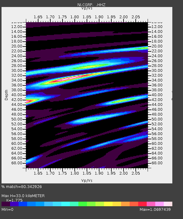
CGRP Cima Grappa - Earthquake Result Viewer
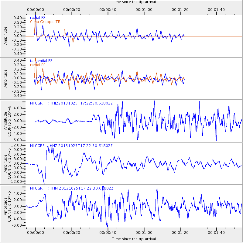
Earthquake location: Off East Coast Of Honshu, Japan
Earthquake latitude/longitude: 37.2/144.7
Earthquake time(UTC): 2013/10/25 (298) 17:10:19 GMT
Earthquake Depth: 35 km
Earthquake Magnitude: 7.1 MWW, 7.1 MWW, 7.1 MWB, 7.1 MWC, 7.2 MWC, 7.5 MI
Earthquake Catalog/Contributor: NEIC PDE/NEIC COMCAT
Network: NI North-East Italy Broadband Network
Station: CGRP Cima Grappa
Lat/Lon: 45.88 N/11.80 E
Elevation: 1757 m
Distance: 87.1 deg
Az: 329.153 deg
Baz: 35.904 deg
Ray Param: 0.043526966
Estimated Moho Depth: 33.0 km
Estimated Crust Vp/Vs: 1.77
Assumed Crust Vp: 6.155 km/s
Estimated Crust Vs: 3.468 km/s
Estimated Crust Poisson's Ratio: 0.27
Radial Match: 80.342926 %
Radial Bump: 400
Transverse Match: 80.98664 %
Transverse Bump: 400
SOD ConfigId: 626651
Insert Time: 2014-04-19 05:56:31.882 +0000
GWidth: 2.5
Max Bumps: 400
Tol: 0.001

Signal To Noise

ChannelStoNSTALTA
NI:CGRP: :HHZ:20131025T17:22:30.61802Z28.7189565.7630623E-62.0067102E-7
NI:CGRP: :HHN:20131025T17:22:30.61802Z8.001321.6012594E-62.0012442E-7
NI:CGRP: :HHE:20131025T17:22:30.61802Z3.42020631.1317173E-63.3089157E-7
Arrivals
Ps4.2 SECOND
PpPs15 SECOND
PsPs/PpSs19 SECOND