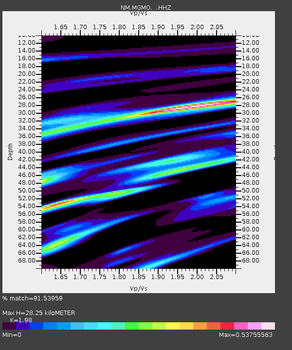
MGMO Mountain Grove, MO - Earthquake Result Viewer

Earthquake location: Off East Coast Of Honshu, Japan
Earthquake latitude/longitude: 37.2/144.7
Earthquake time(UTC): 2013/10/25 (298) 17:10:19 GMT
Earthquake Depth: 35 km
Earthquake Magnitude: 7.1 MWW, 7.1 MWW, 7.1 MWB, 7.1 MWC, 7.2 MWC, 7.5 MI
Earthquake Catalog/Contributor: NEIC PDE/NEIC COMCAT
Network: NM Cooperative New Madrid Seismic Network
Station: MGMO Mountain Grove, MO
Lat/Lon: 37.15 N/92.27 W
Elevation: 453 m
Distance: 89.2 deg
Az: 42.036 deg
Baz: 317.966 deg
Ray Param: 0.041953836
Estimated Moho Depth: 28.25 km
Estimated Crust Vp/Vs: 1.98
Assumed Crust Vp: 6.53 km/s
Estimated Crust Vs: 3.298 km/s
Estimated Crust Poisson's Ratio: 0.33
Radial Match: 91.53959 %
Radial Bump: 246
Transverse Match: 85.883736 %
Transverse Bump: 400
SOD ConfigId: 626651
Insert Time: 2014-04-19 05:57:01.869 +0000
GWidth: 2.5
Max Bumps: 400
Tol: 0.001

Signal To Noise

ChannelStoNSTALTA
NM:MGMO: :HHZ:20131025T17:22:40.777993Z17.5970633.141524E-61.7852548E-7
NM:MGMO: :HHN:20131025T17:22:40.777993Z6.1645521.0499921E-61.7032737E-7
NM:MGMO: :HHE:20131025T17:22:40.777993Z4.35998736.8449083E-71.5699378E-7
Arrivals
Ps4.3 SECOND
PpPs13 SECOND
PsPs/PpSs17 SECOND