You are here: Home > Network List > II - Global Seismograph Network (GSN - IRIS/IDA) Stations List
> Station TLY Talaya, Russia > Earthquake Result Viewer
TLY Talaya, Russia - Earthquake Result Viewer

| Earthquake location: |
Cyprus Region |
| Earthquake latitude/longitude: |
34.6/32.1 |
| Earthquake time(UTC): |
1996/10/09 (283) 13:10:52 GMT |
| Earthquake Depth: |
33 km |
| Earthquake Magnitude: |
6.4 MB, 6.8 MS, 7.2 UNKNOWN, 6.8 MW |
| Earthquake Catalog/Contributor: |
WHDF/NEIC |
|
| Network: |
II Global Seismograph Network (GSN - IRIS/IDA) |
| Station: |
TLY Talaya, Russia |
| Lat/Lon: |
51.68 N/103.64 E |
| Elevation: |
579 m |
|
| Distance: |
52.8 deg |
| Az: |
47.854 deg |
| Baz: |
280.621 deg |
| Ray Param: |
0.06647146 |
| Estimated Moho Depth: |
47.5 km |
| Estimated Crust Vp/Vs: |
1.75 |
| Assumed Crust Vp: |
6.419 km/s |
| Estimated Crust Vs: |
3.668 km/s |
| Estimated Crust Poisson's Ratio: |
0.26 |
|
| Radial Match: |
98.051506 % |
| Radial Bump: |
263 |
| Transverse Match: |
92.73026 % |
| Transverse Bump: |
400 |
| SOD ConfigId: |
6273 |
| Insert Time: |
2010-03-01 17:29:53.397 +0000 |
| GWidth: |
2.5 |
| Max Bumps: |
400 |
| Tol: |
0.001 |
|
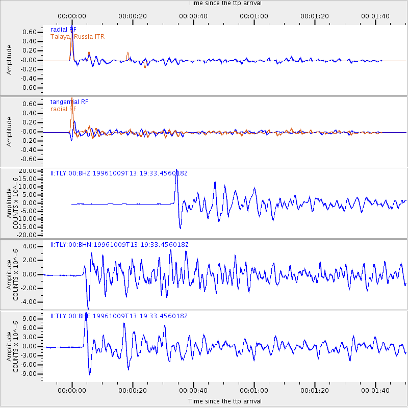
Signal To Noise
| Channel | StoN | STA | LTA |
| II:TLY:00:BHN:19961009T13:19:33.456018Z | 7.0017076 | 5.325472E-7 | 7.6059614E-8 |
| II:TLY:00:BHE:19961009T13:19:33.456018Z | 65.29457 | 3.695927E-6 | 5.6603895E-8 |
| II:TLY:00:BHZ:19961009T13:19:33.456018Z | 86.65534 | 6.9542075E-6 | 8.025134E-8 |
| Arrivals |
| Ps | 5.9 SECOND |
| PpPs | 19 SECOND |
| PsPs/PpSs | 25 SECOND |


