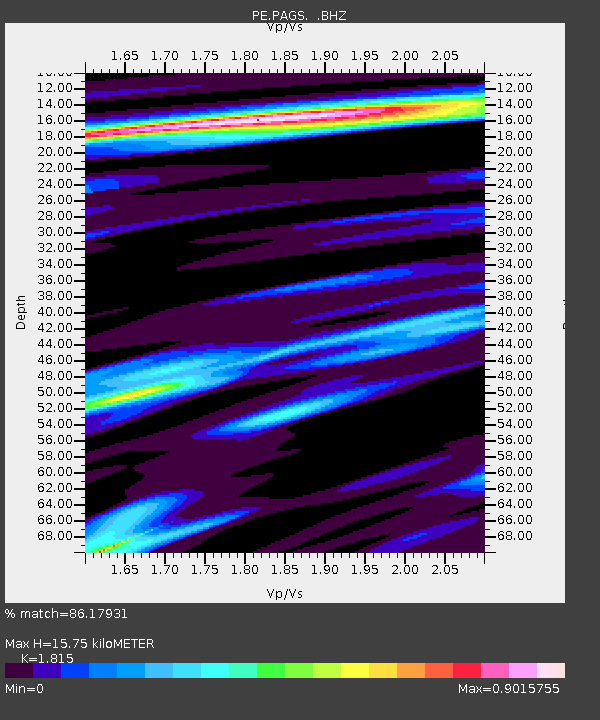
PAGS PA Geological Survey - Earthquake Result Viewer

Earthquake location: Off East Coast Of Honshu, Japan
Earthquake latitude/longitude: 37.2/144.7
Earthquake time(UTC): 2013/10/25 (298) 17:10:19 GMT
Earthquake Depth: 35 km
Earthquake Magnitude: 7.1 MWW, 7.1 MWW, 7.1 MWB, 7.1 MWC, 7.2 MWC, 7.5 MI
Earthquake Catalog/Contributor: NEIC PDE/NEIC COMCAT
Network: PE Penn State Network
Station: PAGS PA Geological Survey
Lat/Lon: 40.23 N/76.72 W
Elevation: 120 m
Distance: 94.1 deg
Az: 30.495 deg
Baz: 328.025 deg
Ray Param: 0.041100934
Estimated Moho Depth: 15.75 km
Estimated Crust Vp/Vs: 1.82
Assumed Crust Vp: 6.121 km/s
Estimated Crust Vs: 3.372 km/s
Estimated Crust Poisson's Ratio: 0.28
Radial Match: 86.17931 %
Radial Bump: 400
Transverse Match: 61.68213 %
Transverse Bump: 400
SOD ConfigId: 626651
Insert Time: 2014-04-19 05:58:38.393 +0000
GWidth: 2.5
Max Bumps: 400
Tol: 0.001

Signal To Noise

ChannelStoNSTALTA
PE:PAGS: :BHZ:20131025T17:23:03.360024Z9.2317012.727614E-62.954617E-7
PE:PAGS: :BHN:20131025T17:23:03.360024Z2.51748688.389593E-73.332527E-7
PE:PAGS: :BHE:20131025T17:23:03.360024Z3.02860886.563994E-72.1673297E-7
Arrivals
Ps2.1 SECOND
PpPs7.1 SECOND
PsPs/PpSs9.3 SECOND