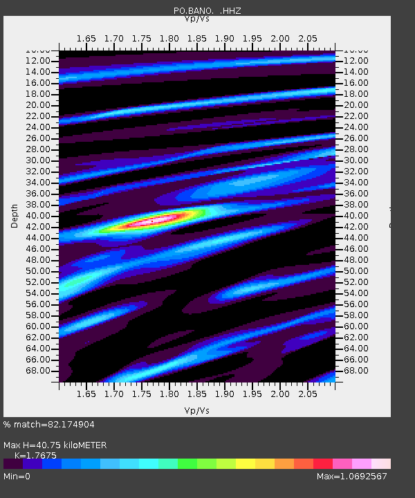
BANO BANCROFT, ON - Earthquake Result Viewer

Earthquake location: Off East Coast Of Honshu, Japan
Earthquake latitude/longitude: 37.2/144.7
Earthquake time(UTC): 2013/10/25 (298) 17:10:19 GMT
Earthquake Depth: 35 km
Earthquake Magnitude: 7.1 MWW, 7.1 MWW, 7.1 MWB, 7.1 MWC, 7.2 MWC, 7.5 MI
Earthquake Catalog/Contributor: NEIC PDE/NEIC COMCAT
Network: PO Portable Observatories for Lithospheric Analysis and Research Investigating Seis
Station: BANO BANCROFT, ON
Lat/Lon: 45.02 N/77.93 W
Elevation: 360 m
Distance: 89.6 deg
Az: 28.684 deg
Baz: 327.27 deg
Ray Param: 0.04172806
Estimated Moho Depth: 40.75 km
Estimated Crust Vp/Vs: 1.77
Assumed Crust Vp: 6.577 km/s
Estimated Crust Vs: 3.721 km/s
Estimated Crust Poisson's Ratio: 0.26
Radial Match: 82.174904 %
Radial Bump: 297
Transverse Match: 45.605186 %
Transverse Bump: 400
SOD ConfigId: 626651
Insert Time: 2014-04-19 05:59:09.972 +0000
GWidth: 2.5
Max Bumps: 400
Tol: 0.001

Signal To Noise

ChannelStoNSTALTA
PO:BANO: :HHZ:20131025T17:22:42.530007Z12.7864611.6237848E-61.2699252E-7
PO:BANO: :HHN:20131025T17:22:42.530007Z4.57426.0077474E-71.3133983E-7
PO:BANO: :HHE:20131025T17:22:42.530007Z2.76022347.3096635E-72.6482147E-7
Arrivals
Ps4.9 SECOND
PpPs17 SECOND
PsPs/PpSs22 SECOND