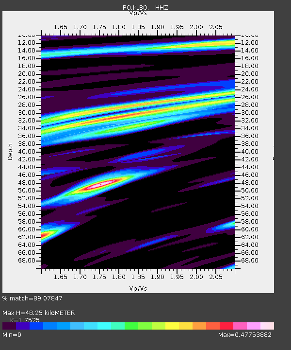
KLBO KILLBEAR, ON - Earthquake Result Viewer

Earthquake location: Off East Coast Of Honshu, Japan
Earthquake latitude/longitude: 37.2/144.7
Earthquake time(UTC): 2013/10/25 (298) 17:10:19 GMT
Earthquake Depth: 35 km
Earthquake Magnitude: 7.1 MWW, 7.1 MWW, 7.1 MWB, 7.1 MWC, 7.2 MWC, 7.5 MI
Earthquake Catalog/Contributor: NEIC PDE/NEIC COMCAT
Network: PO Portable Observatories for Lithospheric Analysis and Research Investigating Seis
Station: KLBO KILLBEAR, ON
Lat/Lon: 45.36 N/80.21 W
Elevation: 177 m
Distance: 88.4 deg
Az: 29.845 deg
Baz: 325.674 deg
Ray Param: 0.042541128
Estimated Moho Depth: 48.25 km
Estimated Crust Vp/Vs: 1.75
Assumed Crust Vp: 6.53 km/s
Estimated Crust Vs: 3.726 km/s
Estimated Crust Poisson's Ratio: 0.26
Radial Match: 89.07847 %
Radial Bump: 359
Transverse Match: 82.58848 %
Transverse Bump: 400
SOD ConfigId: 626651
Insert Time: 2014-04-19 05:59:39.962 +0000
GWidth: 2.5
Max Bumps: 400
Tol: 0.001

Signal To Noise

ChannelStoNSTALTA
PO:KLBO: :HHZ:20131025T17:22:37.030007Z14.6831681.7294723E-61.17786044E-7
PO:KLBO: :HHN:20131025T17:22:37.030007Z3.17423635.6209825E-71.770814E-7
PO:KLBO: :HHE:20131025T17:22:37.030007Z1.35668471.6058978E-71.1836927E-7
Arrivals
Ps5.7 SECOND
PpPs20 SECOND
PsPs/PpSs26 SECOND