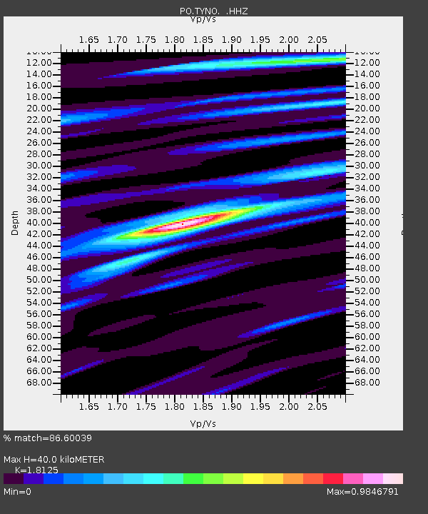
TYNO TYNESIDE, ON - Earthquake Result Viewer

Earthquake location: Off East Coast Of Honshu, Japan
Earthquake latitude/longitude: 37.2/144.7
Earthquake time(UTC): 2013/10/25 (298) 17:10:19 GMT
Earthquake Depth: 35 km
Earthquake Magnitude: 7.1 MWW, 7.1 MWW, 7.1 MWB, 7.1 MWC, 7.2 MWC, 7.5 MI
Earthquake Catalog/Contributor: NEIC PDE/NEIC COMCAT
Network: PO Portable Observatories for Lithospheric Analysis and Research Investigating Seis
Station: TYNO TYNESIDE, ON
Lat/Lon: 43.10 N/79.87 W
Elevation: 205 m
Distance: 90.4 deg
Az: 30.912 deg
Baz: 325.922 deg
Ray Param: 0.041668482
Estimated Moho Depth: 40.0 km
Estimated Crust Vp/Vs: 1.81
Assumed Crust Vp: 6.419 km/s
Estimated Crust Vs: 3.542 km/s
Estimated Crust Poisson's Ratio: 0.28
Radial Match: 86.60039 %
Radial Bump: 400
Transverse Match: 65.60157 %
Transverse Bump: 400
SOD ConfigId: 626651
Insert Time: 2014-04-19 06:00:19.699 +0000
GWidth: 2.5
Max Bumps: 400
Tol: 0.001

Signal To Noise

ChannelStoNSTALTA
PO:TYNO: :HHZ:20131025T17:22:46.400002Z19.9888632.545738E-61.2735782E-7
PO:TYNO: :HHN:20131025T17:22:46.400002Z4.01212939.437398E-72.3522168E-7
PO:TYNO: :HHE:20131025T17:22:46.400002Z2.4600185.502587E-72.2368077E-7
Arrivals
Ps5.2 SECOND
PpPs17 SECOND
PsPs/PpSs22 SECOND