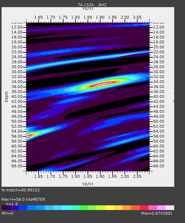
152A Waverly Hall, GA, USA - Earthquake Result Viewer

Earthquake location: Off East Coast Of Honshu, Japan
Earthquake latitude/longitude: 37.2/144.7
Earthquake time(UTC): 2013/10/25 (298) 17:10:19 GMT
Earthquake Depth: 35 km
Earthquake Magnitude: 7.1 MWW, 7.1 MWW, 7.1 MWB, 7.1 MWC, 7.2 MWC, 7.5 MI
Earthquake Catalog/Contributor: NEIC PDE/NEIC COMCAT
Network: TA USArray Transportable Network (new EarthScope stations)
Station: 152A Waverly Hall, GA, USA
Lat/Lon: 32.67 N/84.72 W
Elevation: 214 m
Distance: 96.6 deg
Az: 40.131 deg
Baz: 322.372 deg
Ray Param: 0.040437102
Estimated Moho Depth: 56.0 km
Estimated Crust Vp/Vs: 1.60
Assumed Crust Vp: 6.719 km/s
Estimated Crust Vs: 4.2 km/s
Estimated Crust Poisson's Ratio: 0.18
Radial Match: 90.99182 %
Radial Bump: 314
Transverse Match: 66.08392 %
Transverse Bump: 400
SOD ConfigId: 626651
Insert Time: 2014-04-19 06:02:43.830 +0000
GWidth: 2.5
Max Bumps: 400
Tol: 0.001

Signal To Noise

ChannelStoNSTALTA
TA:152A: :BHZ:20131025T17:23:14.69999Z15.3730521.8889431E-61.2287366E-7
TA:152A: :BHN:20131025T17:23:14.69999Z1.68770674.3449646E-72.5744782E-7
TA:152A: :BHE:20131025T17:23:14.69999Z1.9505685.0975626E-72.6133733E-7
Arrivals
Ps5.1 SECOND
PpPs21 SECOND
PsPs/PpSs26 SECOND