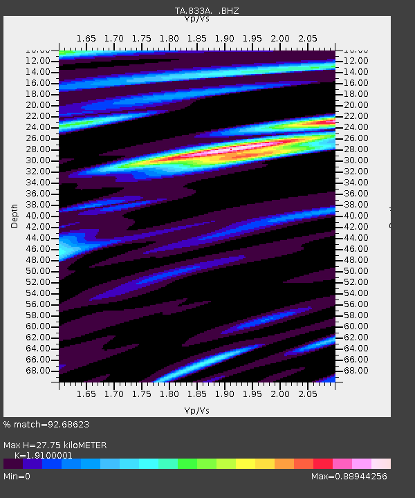
833A Chaparral WMA, Artesia Wells, TX, USA - Earthquake Result Viewer
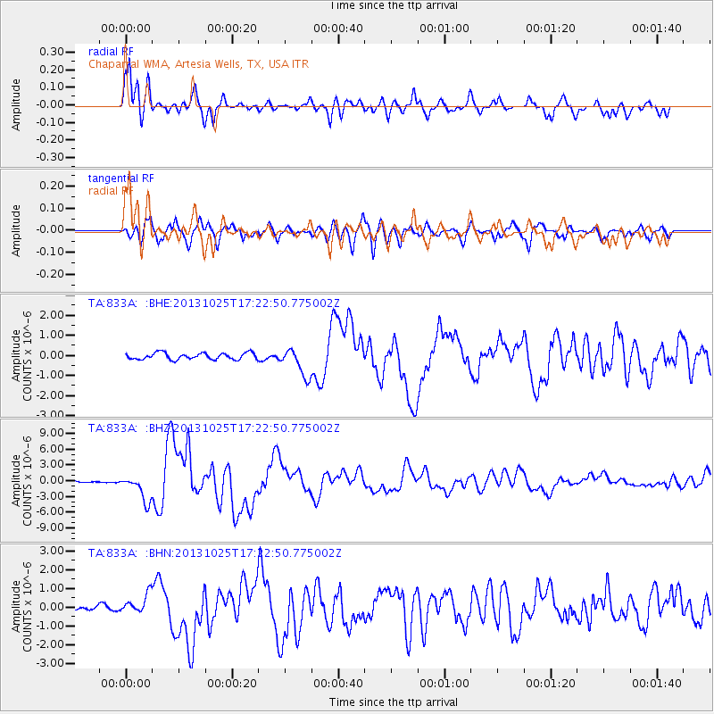
Earthquake location: Off East Coast Of Honshu, Japan
Earthquake latitude/longitude: 37.2/144.7
Earthquake time(UTC): 2013/10/25 (298) 17:10:19 GMT
Earthquake Depth: 35 km
Earthquake Magnitude: 7.1 MWW, 7.1 MWW, 7.1 MWB, 7.1 MWC, 7.2 MWC, 7.5 MI
Earthquake Catalog/Contributor: NEIC PDE/NEIC COMCAT
Network: TA USArray Transportable Network (new EarthScope stations)
Station: 833A Chaparral WMA, Artesia Wells, TX, USA
Lat/Lon: 28.32 N/99.39 W
Elevation: 171 m
Distance: 91.4 deg
Az: 52.466 deg
Baz: 314.058 deg
Ray Param: 0.041600943
Estimated Moho Depth: 27.75 km
Estimated Crust Vp/Vs: 1.91
Assumed Crust Vp: 6.347 km/s
Estimated Crust Vs: 3.323 km/s
Estimated Crust Poisson's Ratio: 0.31
Radial Match: 92.68623 %
Radial Bump: 400
Transverse Match: 83.58271 %
Transverse Bump: 400
SOD ConfigId: 626651
Insert Time: 2014-04-19 06:03:20.032 +0000
GWidth: 2.5
Max Bumps: 400
Tol: 0.001

Signal To Noise

ChannelStoNSTALTA
TA:833A: :BHZ:20131025T17:22:50.775002Z15.1603012.546083E-61.6794408E-7
TA:833A: :BHN:20131025T17:22:50.775002Z2.51943785.2929147E-72.1008316E-7
TA:833A: :BHE:20131025T17:22:50.775002Z4.41603957.1052085E-71.6089551E-7
Arrivals
Ps4.1 SECOND
PpPs12 SECOND
PsPs/PpSs17 SECOND