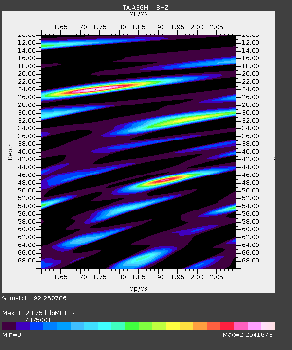
A36M Sachs Harbour, NT, CAN - Earthquake Result Viewer
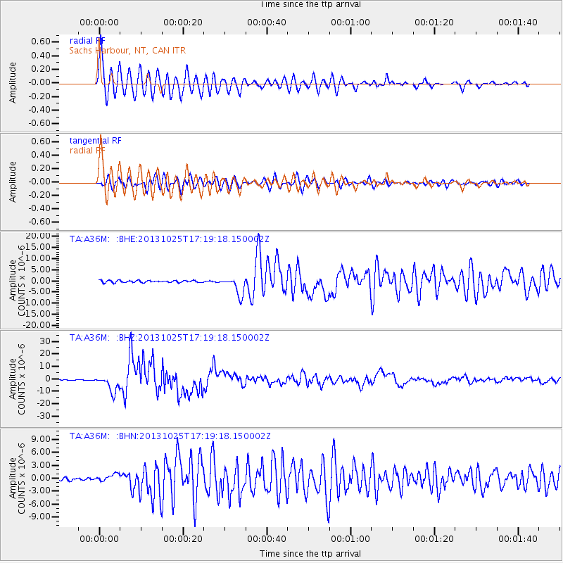
Earthquake location: Off East Coast Of Honshu, Japan
Earthquake latitude/longitude: 37.2/144.7
Earthquake time(UTC): 2013/10/25 (298) 17:10:19 GMT
Earthquake Depth: 35 km
Earthquake Magnitude: 7.1 MWW, 7.1 MWW, 7.1 MWB, 7.1 MWC, 7.2 MWC, 7.5 MI
Earthquake Catalog/Contributor: NEIC PDE/NEIC COMCAT
Network: TA USArray Transportable Network (new EarthScope stations)
Station: A36M Sachs Harbour, NT, CAN
Lat/Lon: 71.99 N/125.25 W
Elevation: 32 m
Distance: 55.2 deg
Az: 22.273 deg
Baz: 283.263 deg
Ray Param: 0.06490435
Estimated Moho Depth: 23.75 km
Estimated Crust Vp/Vs: 1.74
Assumed Crust Vp: 6.24 km/s
Estimated Crust Vs: 3.591 km/s
Estimated Crust Poisson's Ratio: 0.25
Radial Match: 92.250786 %
Radial Bump: 400
Transverse Match: 88.647675 %
Transverse Bump: 400
SOD ConfigId: 626651
Insert Time: 2014-04-19 06:03:26.111 +0000
GWidth: 2.5
Max Bumps: 400
Tol: 0.001

Signal To Noise

ChannelStoNSTALTA
TA:A36M: :BHZ:20131025T17:19:18.150002Z28.9968556.808088E-62.3478711E-7
TA:A36M: :BHN:20131025T17:19:18.150002Z2.09241068.7927725E-74.2022214E-7
TA:A36M: :BHE:20131025T17:19:18.150002Z9.4526194.24049E-64.486048E-7
Arrivals
Ps3.0 SECOND
PpPs9.9 SECOND
PsPs/PpSs13 SECOND