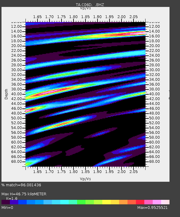
C06D Leavenworth, WQ, USA - Earthquake Result Viewer
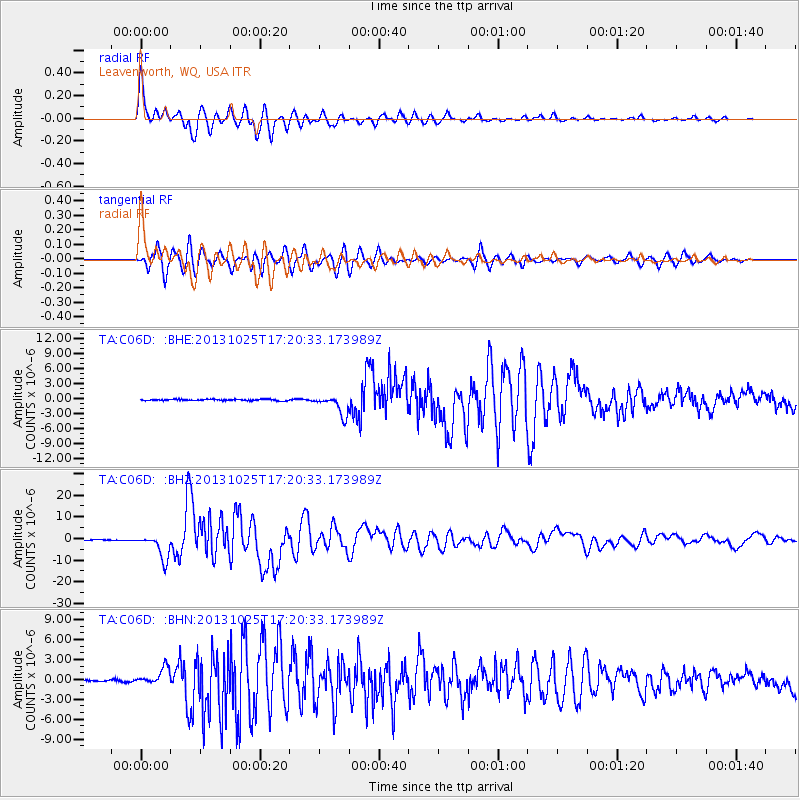
Earthquake location: Off East Coast Of Honshu, Japan
Earthquake latitude/longitude: 37.2/144.7
Earthquake time(UTC): 2013/10/25 (298) 17:10:19 GMT
Earthquake Depth: 35 km
Earthquake Magnitude: 7.1 MWW, 7.1 MWW, 7.1 MWB, 7.1 MWC, 7.2 MWC, 7.5 MI
Earthquake Catalog/Contributor: NEIC PDE/NEIC COMCAT
Network: TA USArray Transportable Network (new EarthScope stations)
Station: C06D Leavenworth, WQ, USA
Lat/Lon: 47.92 N/120.89 W
Elevation: 544 m
Distance: 66.2 deg
Az: 47.127 deg
Baz: 299.482 deg
Ray Param: 0.057708923
Estimated Moho Depth: 46.75 km
Estimated Crust Vp/Vs: 1.60
Assumed Crust Vp: 6.597 km/s
Estimated Crust Vs: 4.123 km/s
Estimated Crust Poisson's Ratio: 0.18
Radial Match: 96.081436 %
Radial Bump: 400
Transverse Match: 94.994804 %
Transverse Bump: 400
SOD ConfigId: 626651
Insert Time: 2014-04-19 06:03:38.138 +0000
GWidth: 2.5
Max Bumps: 400
Tol: 0.001

Signal To Noise

ChannelStoNSTALTA
TA:C06D: :BHZ:20131025T17:20:33.173989Z57.3775525.7914804E-61.0093635E-7
TA:C06D: :BHN:20131025T17:20:33.173989Z11.3051651.2597133E-61.1142811E-7
TA:C06D: :BHE:20131025T17:20:33.173989Z14.0549551.9949803E-61.4194143E-7
Arrivals
Ps4.5 SECOND
PpPs18 SECOND
PsPs/PpSs22 SECOND