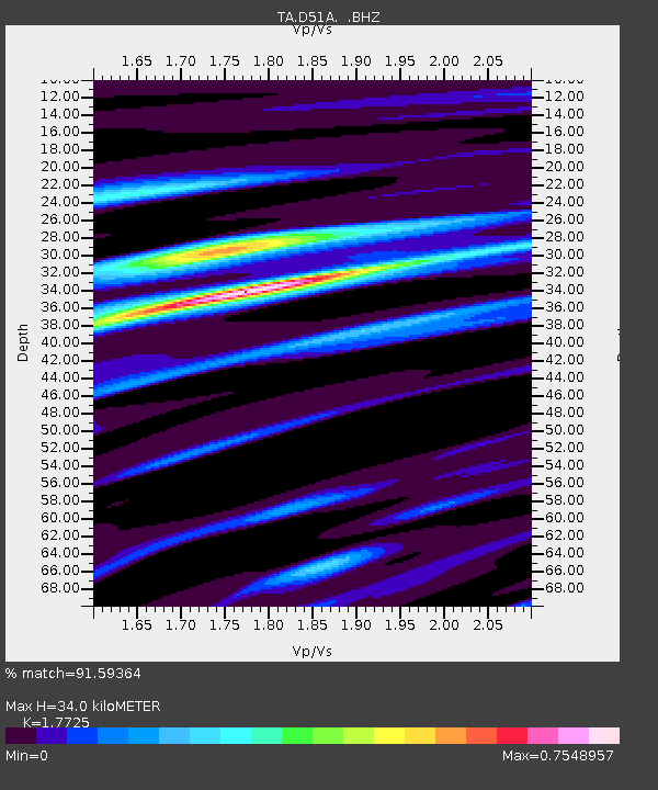
D51A Lot 18 Range III Mazenod Township, QC, CAN - Earthquake Result Viewer

Earthquake location: Off East Coast Of Honshu, Japan
Earthquake latitude/longitude: 37.2/144.7
Earthquake time(UTC): 2013/10/25 (298) 17:10:19 GMT
Earthquake Depth: 35 km
Earthquake Magnitude: 7.1 MWW, 7.1 MWW, 7.1 MWB, 7.1 MWC, 7.2 MWC, 7.5 MI
Earthquake Catalog/Contributor: NEIC PDE/NEIC COMCAT
Network: TA USArray Transportable Network (new EarthScope stations)
Station: D51A Lot 18 Range III Mazenod Township, QC, CAN
Lat/Lon: 47.09 N/79.37 W
Elevation: 282 m
Distance: 87.3 deg
Az: 28.39 deg
Baz: 326.224 deg
Ray Param: 0.04335907
Estimated Moho Depth: 34.0 km
Estimated Crust Vp/Vs: 1.77
Assumed Crust Vp: 6.622 km/s
Estimated Crust Vs: 3.736 km/s
Estimated Crust Poisson's Ratio: 0.27
Radial Match: 91.59364 %
Radial Bump: 400
Transverse Match: 74.26535 %
Transverse Bump: 400
SOD ConfigId: 626651
Insert Time: 2014-04-19 06:04:01.571 +0000
GWidth: 2.5
Max Bumps: 400
Tol: 0.001

Signal To Noise

ChannelStoNSTALTA
TA:D51A: :BHZ:20131025T17:22:31.749978Z13.6389215.540977E-64.0626213E-7
TA:D51A: :BHN:20131025T17:22:31.749978Z3.78535871.8291668E-64.832215E-7
TA:D51A: :BHE:20131025T17:22:31.749978Z3.70523331.3219368E-63.567756E-7
Arrivals
Ps4.1 SECOND
PpPs14 SECOND
PsPs/PpSs18 SECOND