You are here: Home > Network List > TA - USArray Transportable Network (new EarthScope stations) Stations List
> Station D53A Lac Vacive, Pontiac, Mrc, QC, CAN > Earthquake Result Viewer
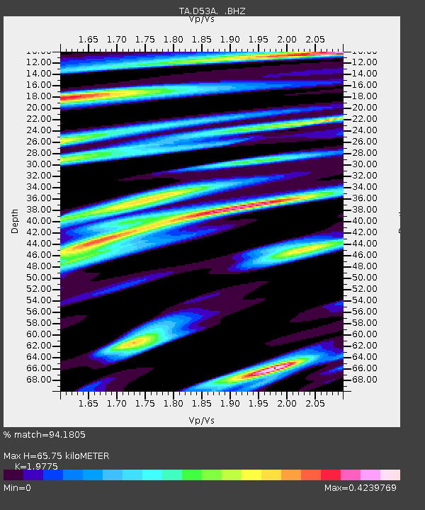
D53A Lac Vacive, Pontiac, Mrc, QC, CAN - Earthquake Result Viewer
| Earthquake location: |
Off East Coast Of Honshu, Japan |
| Earthquake latitude/longitude: |
37.2/144.7 |
| Earthquake time(UTC): |
2013/10/25 (298) 17:10:19 GMT |
| Earthquake Depth: |
35 km |
| Earthquake Magnitude: |
7.1 MWW, 7.1 MWW, 7.1 MWB, 7.1 MWC, 7.2 MWC, 7.5 MI |
| Earthquake Catalog/Contributor: |
NEIC PDE/NEIC COMCAT |
|
| Network: |
TA USArray Transportable Network (new EarthScope stations) |
| Station: |
D53A Lac Vacive, Pontiac, Mrc, QC, CAN |
| Lat/Lon: |
47.08 N/77.70 W |
| Elevation: |
347 m |
|
| Distance: |
88.0 deg |
| Az: |
27.438 deg |
| Baz: |
327.407 deg |
| Ray Param: |
0.042894147 |
| Estimated Moho Depth: |
65.75 km |
| Estimated Crust Vp/Vs: |
1.98 |
| Assumed Crust Vp: |
6.622 km/s |
| Estimated Crust Vs: |
3.349 km/s |
| Estimated Crust Poisson's Ratio: |
0.33 |
|
| Radial Match: |
94.1805 % |
| Radial Bump: |
342 |
| Transverse Match: |
83.60435 % |
| Transverse Bump: |
400 |
| SOD ConfigId: |
626651 |
| Insert Time: |
2014-04-19 06:04:05.817 +0000 |
| GWidth: |
2.5 |
| Max Bumps: |
400 |
| Tol: |
0.001 |
|

Signal To Noise
| Channel | StoN | STA | LTA |
| TA:D53A: :BHZ:20131025T17:22:34.800027Z | 13.011337 | 5.121683E-6 | 3.9363232E-7 |
| TA:D53A: :BHN:20131025T17:22:34.800027Z | 3.4412868 | 1.3956044E-6 | 4.0554724E-7 |
| TA:D53A: :BHE:20131025T17:22:34.800027Z | 2.5655756 | 8.129744E-7 | 3.16878E-7 |
| Arrivals |
| Ps | 9.9 SECOND |
| PpPs | 29 SECOND |
| PsPs/PpSs | 39 SECOND |


