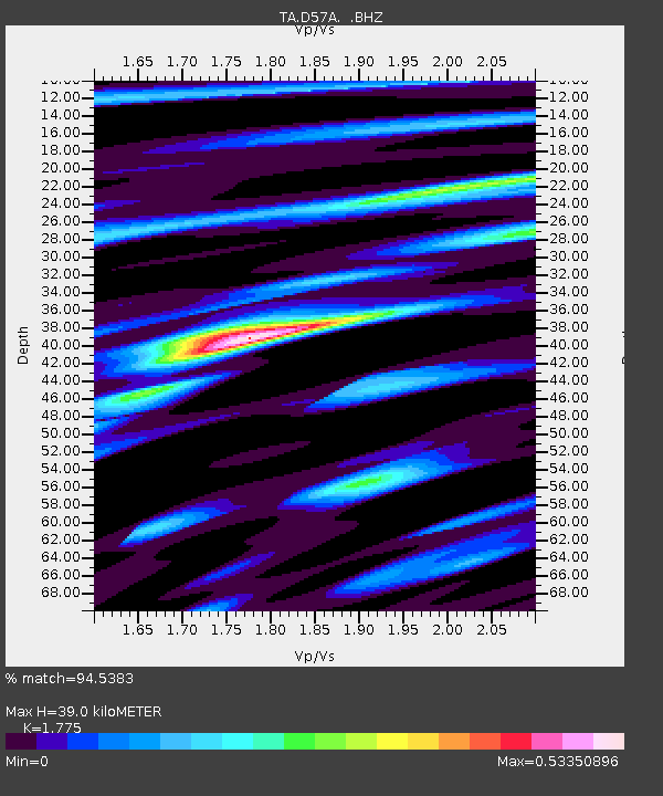
D57A Chemin Vers le Barrage, Saint-Michel-Des-Saints, Q - Earthquake Result Viewer

Earthquake location: Off East Coast Of Honshu, Japan
Earthquake latitude/longitude: 37.2/144.7
Earthquake time(UTC): 2013/10/25 (298) 17:10:19 GMT
Earthquake Depth: 35 km
Earthquake Magnitude: 7.1 MWW, 7.1 MWW, 7.1 MWB, 7.1 MWC, 7.2 MWC, 7.5 MI
Earthquake Catalog/Contributor: NEIC PDE/NEIC COMCAT
Network: TA USArray Transportable Network (new EarthScope stations)
Station: D57A Chemin Vers le Barrage, Saint-Michel-Des-Saints, Q
Lat/Lon: 47.02 N/73.89 W
Elevation: 422 m
Distance: 89.4 deg
Az: 25.241 deg
Baz: 330.138 deg
Ray Param: 0.04185772
Estimated Moho Depth: 39.0 km
Estimated Crust Vp/Vs: 1.77
Assumed Crust Vp: 6.61 km/s
Estimated Crust Vs: 3.724 km/s
Estimated Crust Poisson's Ratio: 0.27
Radial Match: 94.5383 %
Radial Bump: 343
Transverse Match: 84.345146 %
Transverse Bump: 400
SOD ConfigId: 626651
Insert Time: 2014-04-19 06:04:15.703 +0000
GWidth: 2.5
Max Bumps: 400
Tol: 0.001

Signal To Noise

ChannelStoNSTALTA
TA:D57A: :BHZ:20131025T17:22:41.400002Z9.0869655.113355E-65.6271324E-7
TA:D57A: :BHN:20131025T17:22:41.400002Z5.7646151.41546E-62.4554285E-7
TA:D57A: :BHE:20131025T17:22:41.400002Z2.16807468.253468E-73.8068188E-7
Arrivals
Ps4.7 SECOND
PpPs16 SECOND
PsPs/PpSs21 SECOND