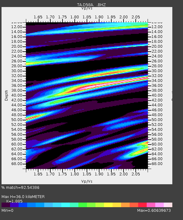
D58A Chemin du LacGrosbois, Trois-Rives, QC, CAN - Earthquake Result Viewer
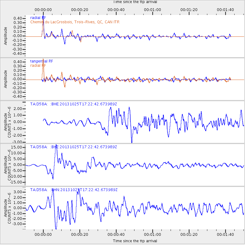
Earthquake location: Off East Coast Of Honshu, Japan
Earthquake latitude/longitude: 37.2/144.7
Earthquake time(UTC): 2013/10/25 (298) 17:10:19 GMT
Earthquake Depth: 35 km
Earthquake Magnitude: 7.1 MWW, 7.1 MWW, 7.1 MWB, 7.1 MWC, 7.2 MWC, 7.5 MI
Earthquake Catalog/Contributor: NEIC PDE/NEIC COMCAT
Network: TA USArray Transportable Network (new EarthScope stations)
Station: D58A Chemin du LacGrosbois, Trois-Rives, QC, CAN
Lat/Lon: 47.10 N/72.88 W
Elevation: 398 m
Distance: 89.6 deg
Az: 24.604 deg
Baz: 330.866 deg
Ray Param: 0.04172618
Estimated Moho Depth: 36.0 km
Estimated Crust Vp/Vs: 1.88
Assumed Crust Vp: 6.61 km/s
Estimated Crust Vs: 3.507 km/s
Estimated Crust Poisson's Ratio: 0.30
Radial Match: 92.54386 %
Radial Bump: 365
Transverse Match: 79.409195 %
Transverse Bump: 400
SOD ConfigId: 626651
Insert Time: 2014-04-19 06:04:18.666 +0000
GWidth: 2.5
Max Bumps: 400
Tol: 0.001

Signal To Noise

ChannelStoNSTALTA
TA:D58A: :BHZ:20131025T17:22:42.673989Z12.1925114.254674E-63.48958E-7
TA:D58A: :BHN:20131025T17:22:42.673989Z3.08142281.1914946E-63.8667028E-7
TA:D58A: :BHE:20131025T17:22:42.673989Z3.03113537.8957805E-72.6048923E-7
Arrivals
Ps4.9 SECOND
PpPs15 SECOND
PsPs/PpSs20 SECOND