D63A Stockholm, ME, USA - Earthquake Result Viewer
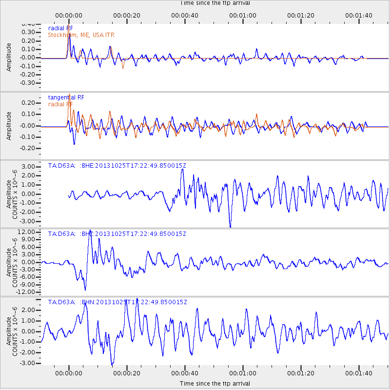
Earthquake location: Off East Coast Of Honshu, Japan
Earthquake latitude/longitude: 37.2/144.7
Earthquake time(UTC): 2013/10/25 (298) 17:10:19 GMT
Earthquake Depth: 35 km
Earthquake Magnitude: 7.1 MWW, 7.1 MWW, 7.1 MWB, 7.1 MWC, 7.2 MWC, 7.5 MI
Earthquake Catalog/Contributor: NEIC PDE/NEIC COMCAT
Network: TA USArray Transportable Network (new EarthScope stations)
Station: D63A Stockholm, ME, USA
Lat/Lon: 47.04 N/68.11 W
Elevation: 256 m
Distance: 91.2 deg
Az: 21.732 deg
Baz: 334.373 deg
Ray Param: 0.041615393
Estimated Moho Depth: 10.25 km
Estimated Crust Vp/Vs: 1.99
Assumed Crust Vp: 6.419 km/s
Estimated Crust Vs: 3.226 km/s
Estimated Crust Poisson's Ratio: 0.33
Radial Match: 84.22244 %
Radial Bump: 400
Transverse Match: 80.43641 %
Transverse Bump: 400
SOD ConfigId: 626651
Insert Time: 2014-04-19 06:04:32.236 +0000
GWidth: 2.5
Max Bumps: 400
Tol: 0.001

Signal To Noise

ChannelStoNSTALTA
TA:D63A: :BHZ:20131025T17:22:49.850015Z8.2352783.6194695E-64.3950783E-7
TA:D63A: :BHN:20131025T17:22:49.850015Z1.73500858.772153E-75.0559714E-7
TA:D63A: :BHE:20131025T17:22:49.850015Z2.9973097.412515E-72.4730565E-7
Arrivals
Ps1.6 SECOND
PpPs4.7 SECOND
PsPs/PpSs6.3 SECOND