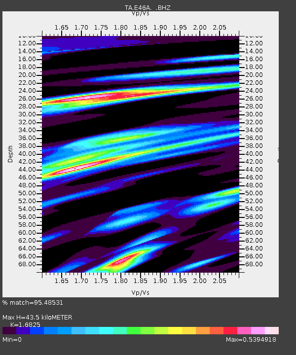
E46A Sault Ste Marie, MI, USA - Earthquake Result Viewer
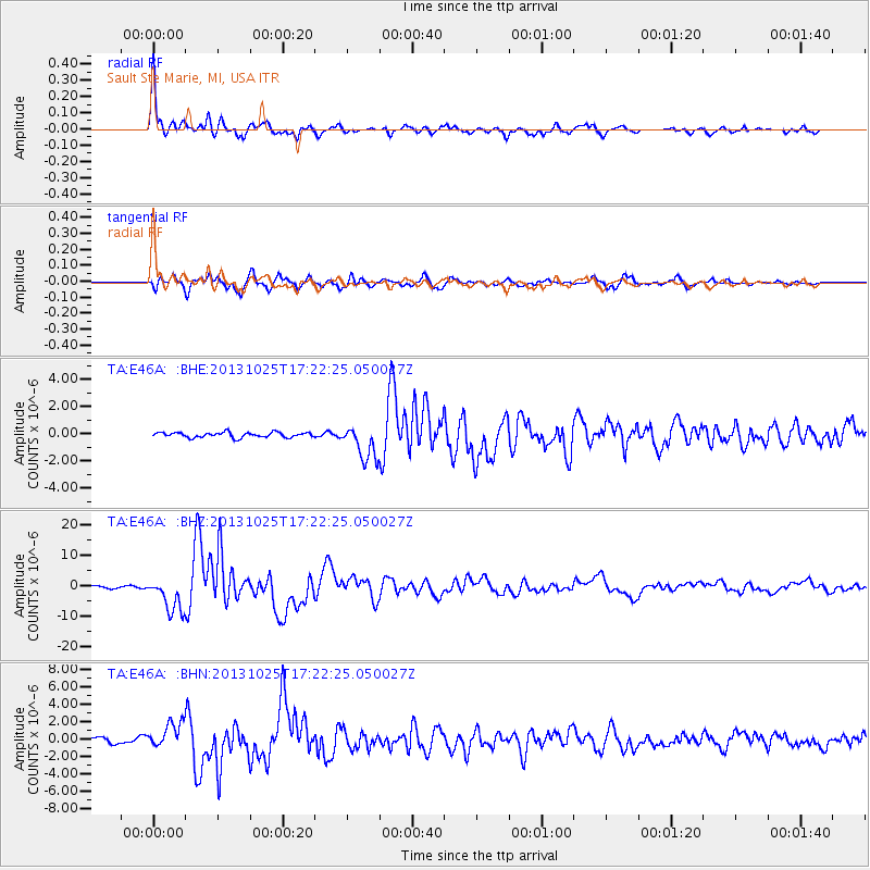
Earthquake location: Off East Coast Of Honshu, Japan
Earthquake latitude/longitude: 37.2/144.7
Earthquake time(UTC): 2013/10/25 (298) 17:10:19 GMT
Earthquake Depth: 35 km
Earthquake Magnitude: 7.1 MWW, 7.1 MWW, 7.1 MWB, 7.1 MWC, 7.2 MWC, 7.5 MI
Earthquake Catalog/Contributor: NEIC PDE/NEIC COMCAT
Network: TA USArray Transportable Network (new EarthScope stations)
Station: E46A Sault Ste Marie, MI, USA
Lat/Lon: 46.37 N/84.31 W
Elevation: 269 m
Distance: 85.9 deg
Az: 31.578 deg
Baz: 322.83 deg
Ray Param: 0.044354476
Estimated Moho Depth: 43.5 km
Estimated Crust Vp/Vs: 1.68
Assumed Crust Vp: 6.467 km/s
Estimated Crust Vs: 3.843 km/s
Estimated Crust Poisson's Ratio: 0.23
Radial Match: 95.48531 %
Radial Bump: 352
Transverse Match: 88.77669 %
Transverse Bump: 400
SOD ConfigId: 626651
Insert Time: 2014-04-19 06:04:44.424 +0000
GWidth: 2.5
Max Bumps: 400
Tol: 0.001

Signal To Noise

ChannelStoNSTALTA
TA:E46A: :BHZ:20131025T17:22:25.050027Z16.7634535.673253E-63.3842986E-7
TA:E46A: :BHN:20131025T17:22:25.050027Z4.5402651.47763E-63.2545017E-7
TA:E46A: :BHE:20131025T17:22:25.050027Z6.81668041.2723049E-61.8664582E-7
Arrivals
Ps4.7 SECOND
PpPs18 SECOND
PsPs/PpSs22 SECOND