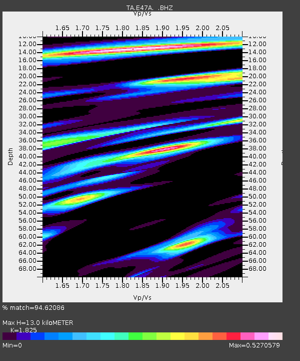
E47A Iron Bridge, ON, CAN - Earthquake Result Viewer

Earthquake location: Off East Coast Of Honshu, Japan
Earthquake latitude/longitude: 37.2/144.7
Earthquake time(UTC): 2013/10/25 (298) 17:10:19 GMT
Earthquake Depth: 35 km
Earthquake Magnitude: 7.1 MWW, 7.1 MWW, 7.1 MWB, 7.1 MWC, 7.2 MWC, 7.5 MI
Earthquake Catalog/Contributor: NEIC PDE/NEIC COMCAT
Network: TA USArray Transportable Network (new EarthScope stations)
Station: E47A Iron Bridge, ON, CAN
Lat/Lon: 46.45 N/83.28 W
Elevation: 246 m
Distance: 86.3 deg
Az: 30.954 deg
Baz: 323.53 deg
Ray Param: 0.044102304
Estimated Moho Depth: 13.0 km
Estimated Crust Vp/Vs: 1.83
Assumed Crust Vp: 6.467 km/s
Estimated Crust Vs: 3.543 km/s
Estimated Crust Poisson's Ratio: 0.29
Radial Match: 94.62086 %
Radial Bump: 337
Transverse Match: 82.469284 %
Transverse Bump: 400
SOD ConfigId: 626651
Insert Time: 2014-04-19 06:04:47.519 +0000
GWidth: 2.5
Max Bumps: 400
Tol: 0.001

Signal To Noise

ChannelStoNSTALTA
TA:E47A: :BHZ:20131025T17:22:26.800027Z12.6444945.1033667E-64.0360388E-7
TA:E47A: :BHN:20131025T17:22:26.800027Z4.47012331.5022317E-63.3606048E-7
TA:E47A: :BHE:20131025T17:22:26.800027Z4.9868131.066818E-62.1392779E-7
Arrivals
Ps1.7 SECOND
PpPs5.6 SECOND
PsPs/PpSs7.2 SECOND