E51A G1948 Merrick Township, ON, CAN - Earthquake Result Viewer
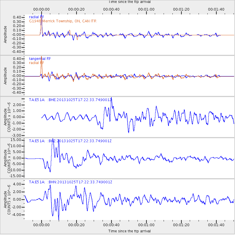
Earthquake location: Off East Coast Of Honshu, Japan
Earthquake latitude/longitude: 37.2/144.7
Earthquake time(UTC): 2013/10/25 (298) 17:10:19 GMT
Earthquake Depth: 35 km
Earthquake Magnitude: 7.1 MWW, 7.1 MWW, 7.1 MWB, 7.1 MWC, 7.2 MWC, 7.5 MI
Earthquake Catalog/Contributor: NEIC PDE/NEIC COMCAT
Network: TA USArray Transportable Network (new EarthScope stations)
Station: E51A G1948 Merrick Township, ON, CAN
Lat/Lon: 46.53 N/79.49 W
Elevation: 369 m
Distance: 87.7 deg
Az: 28.768 deg
Baz: 326.154 deg
Ray Param: 0.043055568
Estimated Moho Depth: 45.25 km
Estimated Crust Vp/Vs: 1.97
Assumed Crust Vp: 6.622 km/s
Estimated Crust Vs: 3.362 km/s
Estimated Crust Poisson's Ratio: 0.33
Radial Match: 92.38256 %
Radial Bump: 400
Transverse Match: 85.57327 %
Transverse Bump: 400
SOD ConfigId: 626651
Insert Time: 2014-04-19 06:04:53.763 +0000
GWidth: 2.5
Max Bumps: 400
Tol: 0.001

Signal To Noise

ChannelStoNSTALTA
TA:E51A: :BHZ:20131025T17:22:33.749001Z12.0543145.1829757E-64.2996854E-7
TA:E51A: :BHN:20131025T17:22:33.749001Z3.66153481.6179666E-64.418821E-7
TA:E51A: :BHE:20131025T17:22:33.749001Z2.66019069.457037E-73.5550224E-7
Arrivals
Ps6.8 SECOND
PpPs20 SECOND
PsPs/PpSs27 SECOND