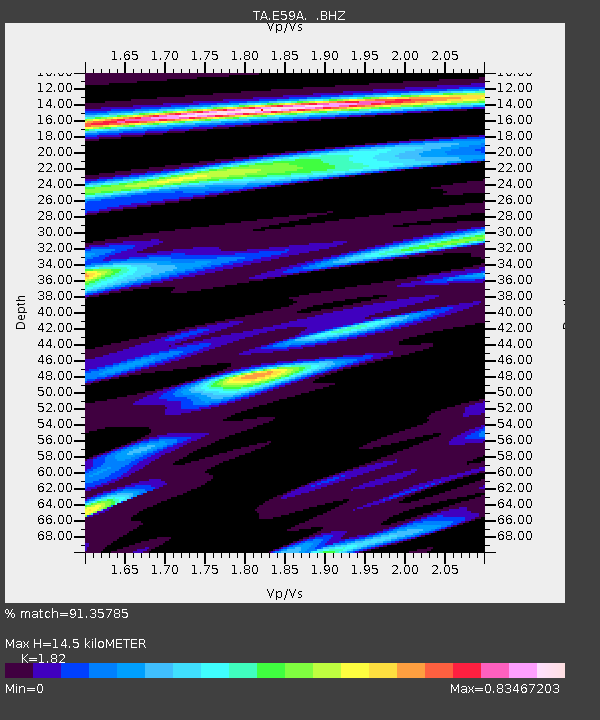
E59A St. Maurice, QC, CAN - Earthquake Result Viewer
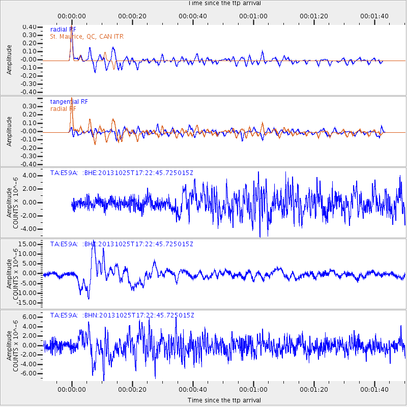
Earthquake location: Off East Coast Of Honshu, Japan
Earthquake latitude/longitude: 37.2/144.7
Earthquake time(UTC): 2013/10/25 (298) 17:10:19 GMT
Earthquake Depth: 35 km
Earthquake Magnitude: 7.1 MWW, 7.1 MWW, 7.1 MWB, 7.1 MWC, 7.2 MWC, 7.5 MI
Earthquake Catalog/Contributor: NEIC PDE/NEIC COMCAT
Network: TA USArray Transportable Network (new EarthScope stations)
Station: E59A St. Maurice, QC, CAN
Lat/Lon: 46.48 N/72.51 W
Elevation: 62 m
Distance: 90.3 deg
Az: 24.679 deg
Baz: 331.136 deg
Ray Param: 0.041678965
Estimated Moho Depth: 14.5 km
Estimated Crust Vp/Vs: 1.82
Assumed Crust Vp: 6.61 km/s
Estimated Crust Vs: 3.632 km/s
Estimated Crust Poisson's Ratio: 0.28
Radial Match: 91.35785 %
Radial Bump: 400
Transverse Match: 77.49642 %
Transverse Bump: 400
SOD ConfigId: 626651
Insert Time: 2014-04-19 06:05:13.552 +0000
GWidth: 2.5
Max Bumps: 400
Tol: 0.001

Signal To Noise

ChannelStoNSTALTA
TA:E59A: :BHZ:20131025T17:22:45.725015Z7.1105734.547574E-66.39551E-7
TA:E59A: :BHN:20131025T17:22:45.725015Z2.15340231.6304402E-67.5714615E-7
TA:E59A: :BHE:20131025T17:22:45.725015Z1.2822097.924995E-76.1807356E-7
Arrivals
Ps1.8 SECOND
PpPs6.1 SECOND
PsPs/PpSs7.9 SECOND