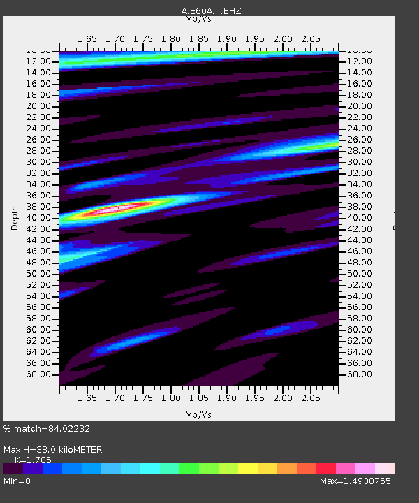
E60A Ste Agathe de Lotbiniere, QC, CAN - Earthquake Result Viewer
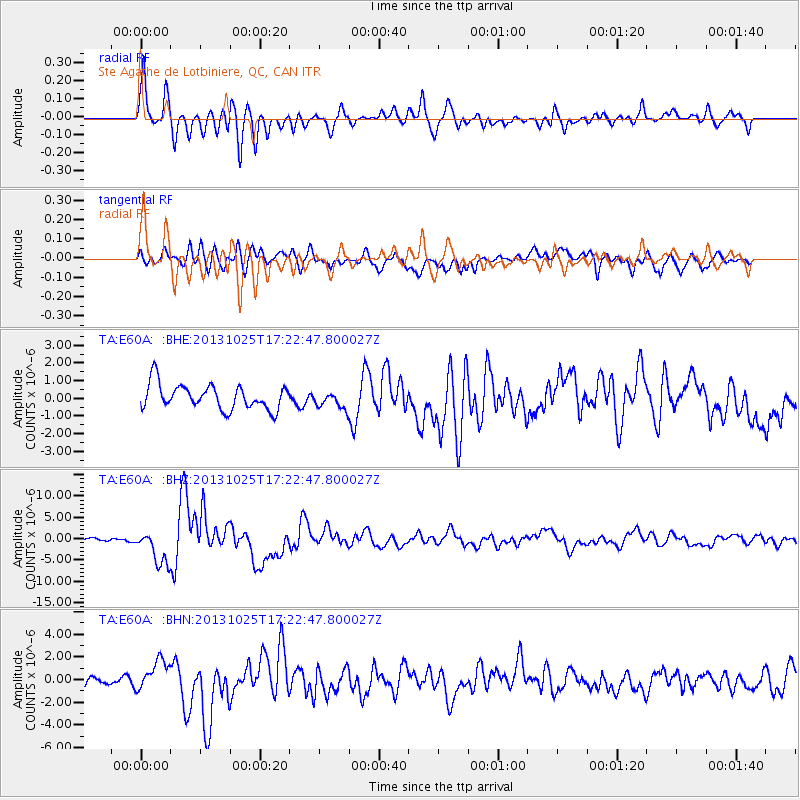
Earthquake location: Off East Coast Of Honshu, Japan
Earthquake latitude/longitude: 37.2/144.7
Earthquake time(UTC): 2013/10/25 (298) 17:10:19 GMT
Earthquake Depth: 35 km
Earthquake Magnitude: 7.1 MWW, 7.1 MWW, 7.1 MWB, 7.1 MWC, 7.2 MWC, 7.5 MI
Earthquake Catalog/Contributor: NEIC PDE/NEIC COMCAT
Network: TA USArray Transportable Network (new EarthScope stations)
Station: E60A Ste Agathe de Lotbiniere, QC, CAN
Lat/Lon: 46.37 N/71.45 W
Elevation: 181 m
Distance: 90.7 deg
Az: 24.085 deg
Baz: 331.91 deg
Ray Param: 0.041646954
Estimated Moho Depth: 38.0 km
Estimated Crust Vp/Vs: 1.71
Assumed Crust Vp: 6.61 km/s
Estimated Crust Vs: 3.877 km/s
Estimated Crust Poisson's Ratio: 0.24
Radial Match: 84.02232 %
Radial Bump: 400
Transverse Match: 70.89088 %
Transverse Bump: 400
SOD ConfigId: 626651
Insert Time: 2014-04-19 06:05:15.050 +0000
GWidth: 2.5
Max Bumps: 400
Tol: 0.001

Signal To Noise

ChannelStoNSTALTA
TA:E60A: :BHZ:20131025T17:22:47.800027Z8.6052694.0472387E-64.7032097E-7
TA:E60A: :BHN:20131025T17:22:47.800027Z2.06971291.23202E-65.952613E-7
TA:E60A: :BHE:20131025T17:22:47.800027Z0.693605364.8541534E-76.9984367E-7
Arrivals
Ps4.1 SECOND
PpPs15 SECOND
PsPs/PpSs19 SECOND