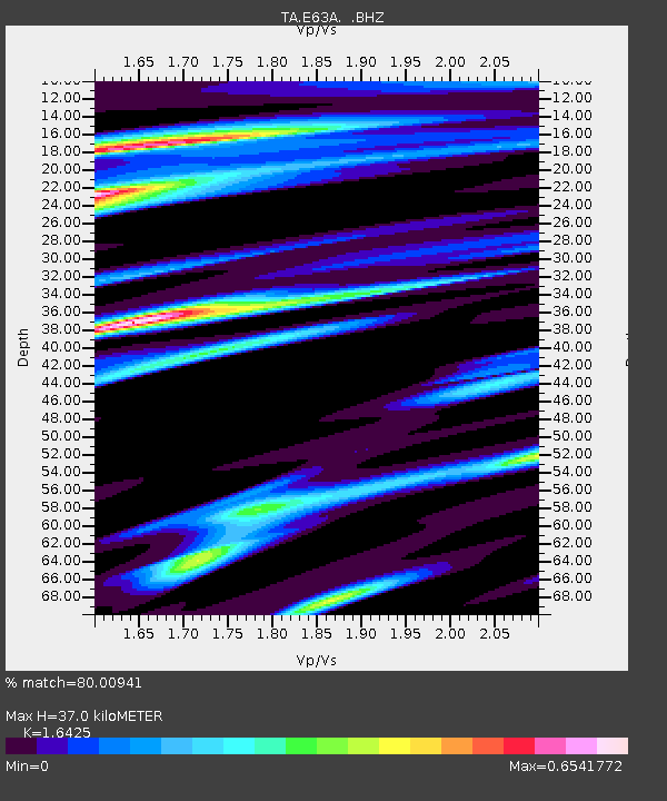
E63A Oxbow, ME, USA - Earthquake Result Viewer
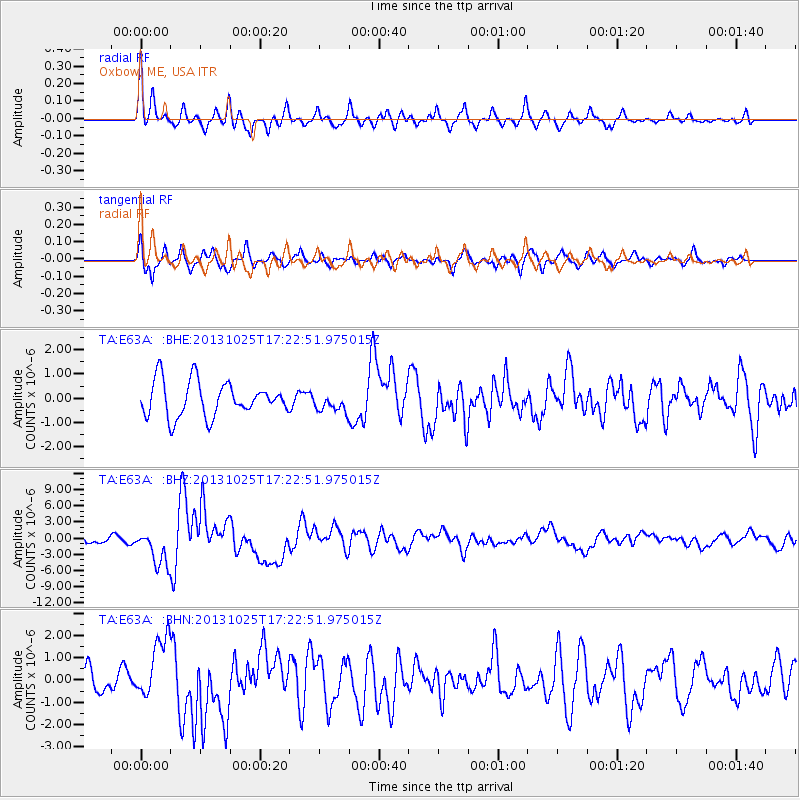
Earthquake location: Off East Coast Of Honshu, Japan
Earthquake latitude/longitude: 37.2/144.7
Earthquake time(UTC): 2013/10/25 (298) 17:10:19 GMT
Earthquake Depth: 35 km
Earthquake Magnitude: 7.1 MWW, 7.1 MWW, 7.1 MWB, 7.1 MWC, 7.2 MWC, 7.5 MI
Earthquake Catalog/Contributor: NEIC PDE/NEIC COMCAT
Network: TA USArray Transportable Network (new EarthScope stations)
Station: E63A Oxbow, ME, USA
Lat/Lon: 46.42 N/68.42 W
Elevation: 238 m
Distance: 91.7 deg
Az: 22.195 deg
Baz: 334.133 deg
Ray Param: 0.041568406
Estimated Moho Depth: 37.0 km
Estimated Crust Vp/Vs: 1.64
Assumed Crust Vp: 6.419 km/s
Estimated Crust Vs: 3.908 km/s
Estimated Crust Poisson's Ratio: 0.21
Radial Match: 80.00941 %
Radial Bump: 400
Transverse Match: 79.39718 %
Transverse Bump: 400
SOD ConfigId: 626651
Insert Time: 2014-04-19 06:05:24.197 +0000
GWidth: 2.5
Max Bumps: 400
Tol: 0.001

Signal To Noise

ChannelStoNSTALTA
TA:E63A: :BHZ:20131025T17:22:51.975015Z4.0256393.3595027E-68.3452653E-7
TA:E63A: :BHN:20131025T17:22:51.975015Z2.85761331.3912477E-64.868565E-7
TA:E63A: :BHE:20131025T17:22:51.975015Z0.54344023.8803307E-77.140308E-7
Arrivals
Ps3.8 SECOND
PpPs15 SECOND
PsPs/PpSs19 SECOND