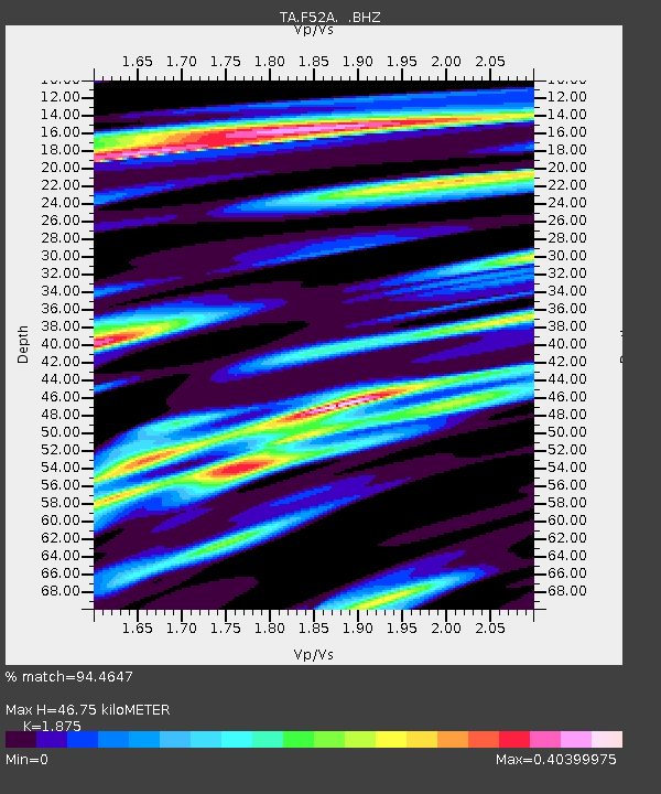
F52A Sundridge, ON, CAN - Earthquake Result Viewer
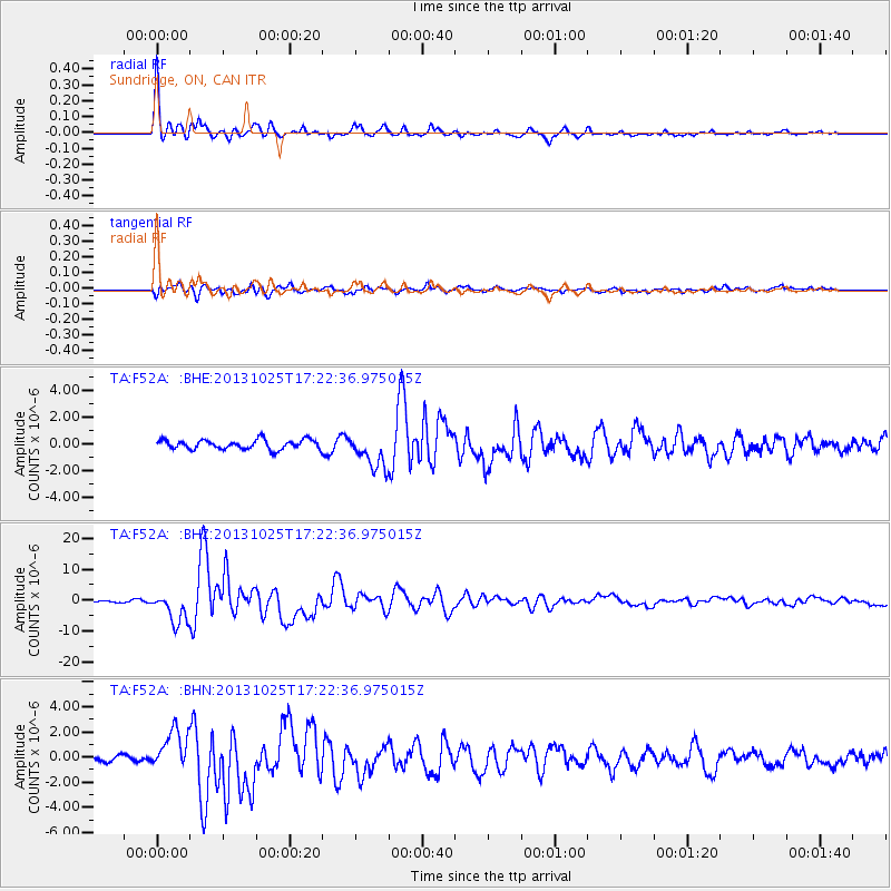
Earthquake location: Off East Coast Of Honshu, Japan
Earthquake latitude/longitude: 37.2/144.7
Earthquake time(UTC): 2013/10/25 (298) 17:10:19 GMT
Earthquake Depth: 35 km
Earthquake Magnitude: 7.1 MWW, 7.1 MWW, 7.1 MWB, 7.1 MWC, 7.2 MWC, 7.5 MI
Earthquake Catalog/Contributor: NEIC PDE/NEIC COMCAT
Network: TA USArray Transportable Network (new EarthScope stations)
Station: F52A Sundridge, ON, CAN
Lat/Lon: 45.80 N/79.32 W
Elevation: 351 m
Distance: 88.4 deg
Az: 29.081 deg
Baz: 326.286 deg
Ray Param: 0.04255119
Estimated Moho Depth: 46.75 km
Estimated Crust Vp/Vs: 1.88
Assumed Crust Vp: 6.577 km/s
Estimated Crust Vs: 3.508 km/s
Estimated Crust Poisson's Ratio: 0.30
Radial Match: 94.4647 %
Radial Bump: 304
Transverse Match: 74.3488 %
Transverse Bump: 400
SOD ConfigId: 626651
Insert Time: 2014-04-19 06:05:52.927 +0000
GWidth: 2.5
Max Bumps: 400
Tol: 0.001

Signal To Noise

ChannelStoNSTALTA
TA:F52A: :BHZ:20131025T17:22:36.975015Z13.2987784.9704836E-63.7375492E-7
TA:F52A: :BHN:20131025T17:22:36.975015Z5.84001351.5537298E-62.66049E-7
TA:F52A: :BHE:20131025T17:22:36.975015Z3.64969131.2917677E-63.539389E-7
Arrivals
Ps6.4 SECOND
PpPs20 SECOND
PsPs/PpSs26 SECOND