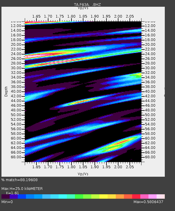
F63A Nahmakanta, Browneville, ME, USA - Earthquake Result Viewer

Earthquake location: Off East Coast Of Honshu, Japan
Earthquake latitude/longitude: 37.2/144.7
Earthquake time(UTC): 2013/10/25 (298) 17:10:19 GMT
Earthquake Depth: 35 km
Earthquake Magnitude: 7.1 MWW, 7.1 MWW, 7.1 MWB, 7.1 MWC, 7.2 MWC, 7.5 MI
Earthquake Catalog/Contributor: NEIC PDE/NEIC COMCAT
Network: TA USArray Transportable Network (new EarthScope stations)
Station: F63A Nahmakanta, Browneville, ME, USA
Lat/Lon: 45.70 N/69.10 W
Elevation: 386 m
Distance: 92.1 deg
Az: 22.938 deg
Baz: 333.62 deg
Ray Param: 0.041502185
Estimated Moho Depth: 25.0 km
Estimated Crust Vp/Vs: 1.61
Assumed Crust Vp: 6.419 km/s
Estimated Crust Vs: 3.987 km/s
Estimated Crust Poisson's Ratio: 0.19
Radial Match: 88.19608 %
Radial Bump: 400
Transverse Match: 74.63232 %
Transverse Bump: 400
SOD ConfigId: 626651
Insert Time: 2014-04-19 06:06:11.861 +0000
GWidth: 2.5
Max Bumps: 400
Tol: 0.001

Signal To Noise

ChannelStoNSTALTA
TA:F63A: :BHZ:20131025T17:22:53.975015Z3.42475842.6244559E-67.663185E-7
TA:F63A: :BHN:20131025T17:22:53.975015Z3.34402851.0038876E-63.0020308E-7
TA:F63A: :BHE:20131025T17:22:53.975015Z1.06237355.958953E-75.609094E-7
Arrivals
Ps2.4 SECOND
PpPs9.9 SECOND
PsPs/PpSs12 SECOND