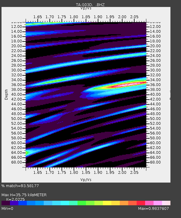
G03D McMinnville, OR, USA - Earthquake Result Viewer
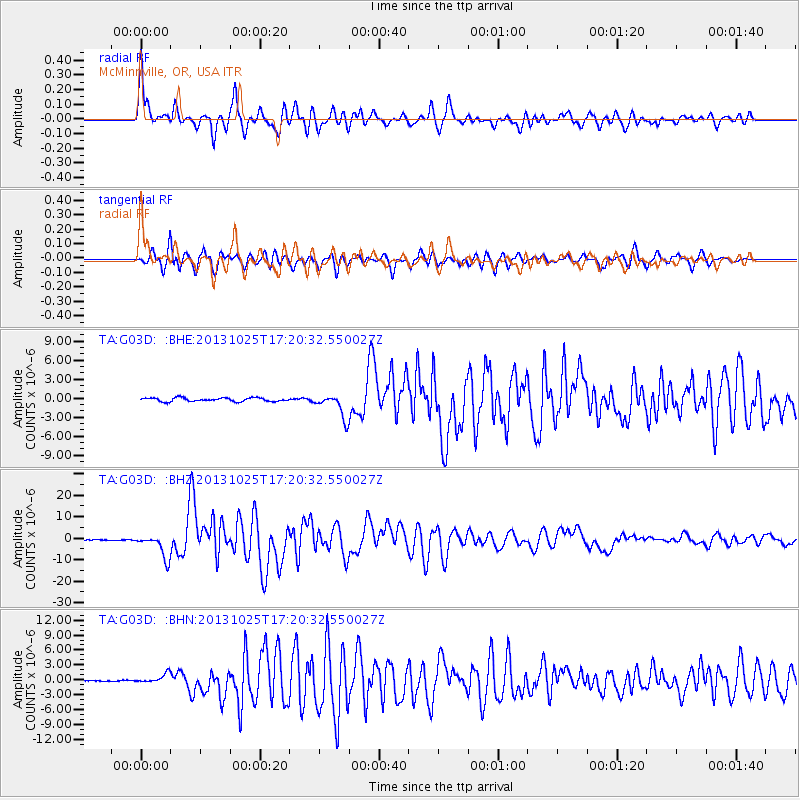
Earthquake location: Off East Coast Of Honshu, Japan
Earthquake latitude/longitude: 37.2/144.7
Earthquake time(UTC): 2013/10/25 (298) 17:10:19 GMT
Earthquake Depth: 35 km
Earthquake Magnitude: 7.1 MWW, 7.1 MWW, 7.1 MWB, 7.1 MWC, 7.2 MWC, 7.5 MI
Earthquake Catalog/Contributor: NEIC PDE/NEIC COMCAT
Network: TA USArray Transportable Network (new EarthScope stations)
Station: G03D McMinnville, OR, USA
Lat/Lon: 45.21 N/123.26 W
Elevation: 222 m
Distance: 66.1 deg
Az: 50.587 deg
Baz: 299.165 deg
Ray Param: 0.057772655
Estimated Moho Depth: 35.75 km
Estimated Crust Vp/Vs: 2.02
Assumed Crust Vp: 6.566 km/s
Estimated Crust Vs: 3.247 km/s
Estimated Crust Poisson's Ratio: 0.34
Radial Match: 93.58177 %
Radial Bump: 400
Transverse Match: 92.026634 %
Transverse Bump: 400
SOD ConfigId: 626651
Insert Time: 2014-04-19 06:06:19.301 +0000
GWidth: 2.5
Max Bumps: 400
Tol: 0.001

Signal To Noise

ChannelStoNSTALTA
TA:G03D: :BHZ:20131025T17:20:32.550027Z46.514835.477999E-61.1776886E-7
TA:G03D: :BHN:20131025T17:20:32.550027Z4.9353559.45558E-71.9158864E-7
TA:G03D: :BHE:20131025T17:20:32.550027Z6.5259351.8725312E-62.8693685E-7
Arrivals
Ps5.8 SECOND
PpPs16 SECOND
PsPs/PpSs22 SECOND