G40A Rib Lake, WI, USA - Earthquake Result Viewer
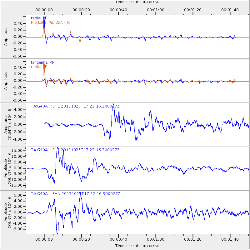
Earthquake location: Off East Coast Of Honshu, Japan
Earthquake latitude/longitude: 37.2/144.7
Earthquake time(UTC): 2013/10/25 (298) 17:10:19 GMT
Earthquake Depth: 35 km
Earthquake Magnitude: 7.1 MWW, 7.1 MWW, 7.1 MWB, 7.1 MWC, 7.2 MWC, 7.5 MI
Earthquake Catalog/Contributor: NEIC PDE/NEIC COMCAT
Network: TA USArray Transportable Network (new EarthScope stations)
Station: G40A Rib Lake, WI, USA
Lat/Lon: 45.27 N/90.20 W
Elevation: 472 m
Distance: 84.2 deg
Az: 35.482 deg
Baz: 318.95 deg
Ray Param: 0.04560633
Estimated Moho Depth: 25.5 km
Estimated Crust Vp/Vs: 1.61
Assumed Crust Vp: 6.571 km/s
Estimated Crust Vs: 4.087 km/s
Estimated Crust Poisson's Ratio: 0.18
Radial Match: 97.34801 %
Radial Bump: 322
Transverse Match: 85.34329 %
Transverse Bump: 400
SOD ConfigId: 626651
Insert Time: 2014-04-19 06:06:26.940 +0000
GWidth: 2.5
Max Bumps: 400
Tol: 0.001

Signal To Noise

ChannelStoNSTALTA
TA:G40A: :BHZ:20131025T17:22:16.300027Z18.6672825.1142856E-62.7397056E-7
TA:G40A: :BHN:20131025T17:22:16.300027Z5.5146741.6542417E-62.999709E-7
TA:G40A: :BHE:20131025T17:22:16.300027Z6.07526451.5451837E-62.5434016E-7
Arrivals
Ps2.4 SECOND
PpPs9.8 SECOND
PsPs/PpSs12 SECOND