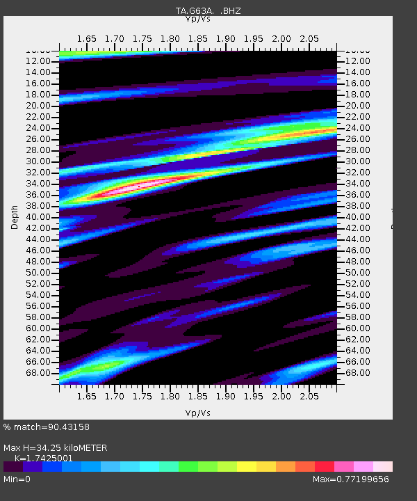
G63A Kingsbury, ME, USA - Earthquake Result Viewer

Earthquake location: Off East Coast Of Honshu, Japan
Earthquake latitude/longitude: 37.2/144.7
Earthquake time(UTC): 2013/10/25 (298) 17:10:19 GMT
Earthquake Depth: 35 km
Earthquake Magnitude: 7.1 MWW, 7.1 MWW, 7.1 MWB, 7.1 MWC, 7.2 MWC, 7.5 MI
Earthquake Catalog/Contributor: NEIC PDE/NEIC COMCAT
Network: TA USArray Transportable Network (new EarthScope stations)
Station: G63A Kingsbury, ME, USA
Lat/Lon: 45.11 N/69.62 W
Elevation: 363 m
Distance: 92.5 deg
Az: 23.526 deg
Baz: 333.23 deg
Ray Param: 0.041444007
Estimated Moho Depth: 34.25 km
Estimated Crust Vp/Vs: 1.74
Assumed Crust Vp: 6.419 km/s
Estimated Crust Vs: 3.684 km/s
Estimated Crust Poisson's Ratio: 0.25
Radial Match: 90.43158 %
Radial Bump: 400
Transverse Match: 74.72814 %
Transverse Bump: 400
SOD ConfigId: 626651
Insert Time: 2014-04-19 06:07:02.264 +0000
GWidth: 2.5
Max Bumps: 400
Tol: 0.001

Signal To Noise

ChannelStoNSTALTA
TA:G63A: :BHZ:20131025T17:22:55.650002Z6.10105852.984479E-64.8917394E-7
TA:G63A: :BHN:20131025T17:22:55.650002Z3.86085411.4965332E-63.8761712E-7
TA:G63A: :BHE:20131025T17:22:55.650002Z1.89988128.004879E-74.2133576E-7
Arrivals
Ps4.0 SECOND
PpPs14 SECOND
PsPs/PpSs18 SECOND