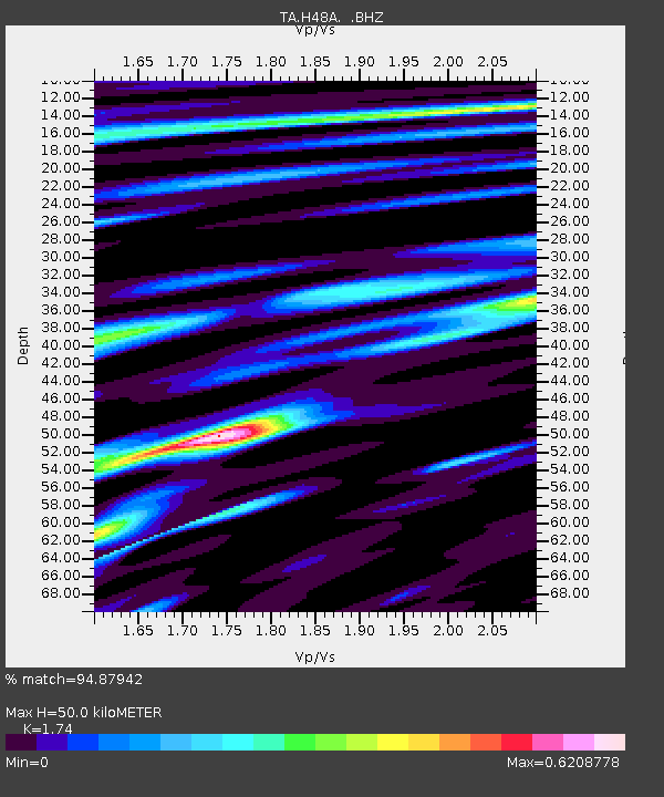
H48A Harrisville, MI, USA - Earthquake Result Viewer
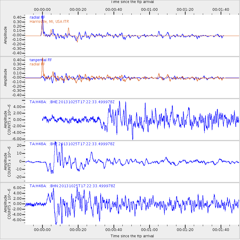
Earthquake location: Off East Coast Of Honshu, Japan
Earthquake latitude/longitude: 37.2/144.7
Earthquake time(UTC): 2013/10/25 (298) 17:10:19 GMT
Earthquake Depth: 35 km
Earthquake Magnitude: 7.1 MWW, 7.1 MWW, 7.1 MWB, 7.1 MWC, 7.2 MWC, 7.5 MI
Earthquake Catalog/Contributor: NEIC PDE/NEIC COMCAT
Network: TA USArray Transportable Network (new EarthScope stations)
Station: H48A Harrisville, MI, USA
Lat/Lon: 44.70 N/83.32 W
Elevation: 244 m
Distance: 87.7 deg
Az: 32.025 deg
Baz: 323.553 deg
Ray Param: 0.043092944
Estimated Moho Depth: 50.0 km
Estimated Crust Vp/Vs: 1.74
Assumed Crust Vp: 6.483 km/s
Estimated Crust Vs: 3.726 km/s
Estimated Crust Poisson's Ratio: 0.25
Radial Match: 94.87942 %
Radial Bump: 400
Transverse Match: 85.85947 %
Transverse Bump: 400
SOD ConfigId: 626651
Insert Time: 2014-04-19 06:07:23.731 +0000
GWidth: 2.5
Max Bumps: 400
Tol: 0.001

Signal To Noise

ChannelStoNSTALTA
TA:H48A: :BHZ:20131025T17:22:33.499978Z10.4906055.146501E-64.9058184E-7
TA:H48A: :BHN:20131025T17:22:33.499978Z3.67002961.5435963E-64.2059506E-7
TA:H48A: :BHE:20131025T17:22:33.499978Z2.33638791.186029E-65.076336E-7
Arrivals
Ps5.8 SECOND
PpPs21 SECOND
PsPs/PpSs26 SECOND