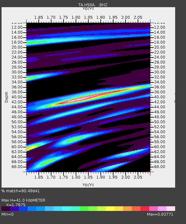
H58A Gabriels, NY, USA - Earthquake Result Viewer

Earthquake location: Off East Coast Of Honshu, Japan
Earthquake latitude/longitude: 37.2/144.7
Earthquake time(UTC): 2013/10/25 (298) 17:10:19 GMT
Earthquake Depth: 35 km
Earthquake Magnitude: 7.1 MWW, 7.1 MWW, 7.1 MWB, 7.1 MWC, 7.2 MWC, 7.5 MI
Earthquake Catalog/Contributor: NEIC PDE/NEIC COMCAT
Network: TA USArray Transportable Network (new EarthScope stations)
Station: H58A Gabriels, NY, USA
Lat/Lon: 44.42 N/74.18 W
Elevation: 537 m
Distance: 91.5 deg
Az: 26.717 deg
Baz: 329.918 deg
Ray Param: 0.04158864
Estimated Moho Depth: 41.0 km
Estimated Crust Vp/Vs: 1.80
Assumed Crust Vp: 6.419 km/s
Estimated Crust Vs: 3.571 km/s
Estimated Crust Poisson's Ratio: 0.28
Radial Match: 90.49641 %
Radial Bump: 400
Transverse Match: 66.14512 %
Transverse Bump: 400
SOD ConfigId: 626651
Insert Time: 2014-04-19 06:07:40.366 +0000
GWidth: 2.5
Max Bumps: 400
Tol: 0.001

Signal To Noise

ChannelStoNSTALTA
TA:H58A: :BHZ:20131025T17:22:51.350015Z7.9200343.411994E-64.3080544E-7
TA:H58A: :BHN:20131025T17:22:51.350015Z2.2987191.0793699E-64.695528E-7
TA:H58A: :BHE:20131025T17:22:51.350015Z2.07630047.692475E-73.704895E-7
Arrivals
Ps5.2 SECOND
PpPs18 SECOND
PsPs/PpSs23 SECOND