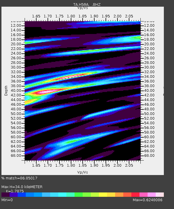
H59A Cadyville, NY, USA - Earthquake Result Viewer

Earthquake location: Off East Coast Of Honshu, Japan
Earthquake latitude/longitude: 37.2/144.7
Earthquake time(UTC): 2013/10/25 (298) 17:10:19 GMT
Earthquake Depth: 35 km
Earthquake Magnitude: 7.1 MWW, 7.1 MWW, 7.1 MWB, 7.1 MWC, 7.2 MWC, 7.5 MI
Earthquake Catalog/Contributor: NEIC PDE/NEIC COMCAT
Network: TA USArray Transportable Network (new EarthScope stations)
Station: H59A Cadyville, NY, USA
Lat/Lon: 44.65 N/73.69 W
Elevation: 355 m
Distance: 91.5 deg
Az: 26.3 deg
Baz: 330.271 deg
Ray Param: 0.041592132
Estimated Moho Depth: 34.0 km
Estimated Crust Vp/Vs: 1.79
Assumed Crust Vp: 6.419 km/s
Estimated Crust Vs: 3.591 km/s
Estimated Crust Poisson's Ratio: 0.27
Radial Match: 86.85017 %
Radial Bump: 400
Transverse Match: 78.27799 %
Transverse Bump: 400
SOD ConfigId: 626651
Insert Time: 2014-04-19 06:07:42.894 +0000
GWidth: 2.5
Max Bumps: 400
Tol: 0.001

Signal To Noise

ChannelStoNSTALTA
TA:H59A: :BHZ:20131025T17:22:51.249978Z8.5075983.0507222E-63.5858795E-7
TA:H59A: :BHN:20131025T17:22:51.249978Z2.83331271.1435751E-64.036177E-7
TA:H59A: :BHE:20131025T17:22:51.249978Z1.38840226.2136627E-74.4754054E-7
Arrivals
Ps4.3 SECOND
PpPs14 SECOND
PsPs/PpSs19 SECOND