I04A Tendick Farm, Oakridge, OR, USA - Earthquake Result Viewer
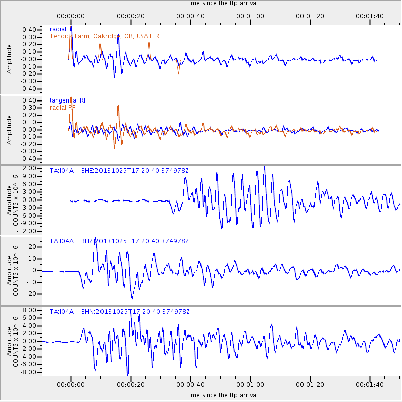
Earthquake location: Off East Coast Of Honshu, Japan
Earthquake latitude/longitude: 37.2/144.7
Earthquake time(UTC): 2013/10/25 (298) 17:10:19 GMT
Earthquake Depth: 35 km
Earthquake Magnitude: 7.1 MWW, 7.1 MWW, 7.1 MWB, 7.1 MWC, 7.2 MWC, 7.5 MI
Earthquake Catalog/Contributor: NEIC PDE/NEIC COMCAT
Network: TA USArray Transportable Network (new EarthScope stations)
Station: I04A Tendick Farm, Oakridge, OR, USA
Lat/Lon: 43.79 N/122.41 W
Elevation: 731 m
Distance: 67.3 deg
Az: 51.599 deg
Baz: 300.16 deg
Ray Param: 0.056962047
Estimated Moho Depth: 40.25 km
Estimated Crust Vp/Vs: 1.67
Assumed Crust Vp: 6.522 km/s
Estimated Crust Vs: 3.911 km/s
Estimated Crust Poisson's Ratio: 0.22
Radial Match: 95.59834 %
Radial Bump: 400
Transverse Match: 93.260376 %
Transverse Bump: 400
SOD ConfigId: 626651
Insert Time: 2014-04-19 06:08:09.713 +0000
GWidth: 2.5
Max Bumps: 400
Tol: 0.001

Signal To Noise

ChannelStoNSTALTA
TA:I04A: :BHZ:20131025T17:20:40.374978Z26.3364775.445298E-62.0675878E-7
TA:I04A: :BHN:20131025T17:20:40.374978Z12.4226291.3765286E-61.1080816E-7
TA:I04A: :BHE:20131025T17:20:40.374978Z8.2329741.8693986E-62.2706237E-7
Arrivals
Ps4.3 SECOND
PpPs16 SECOND
PsPs/PpSs20 SECOND