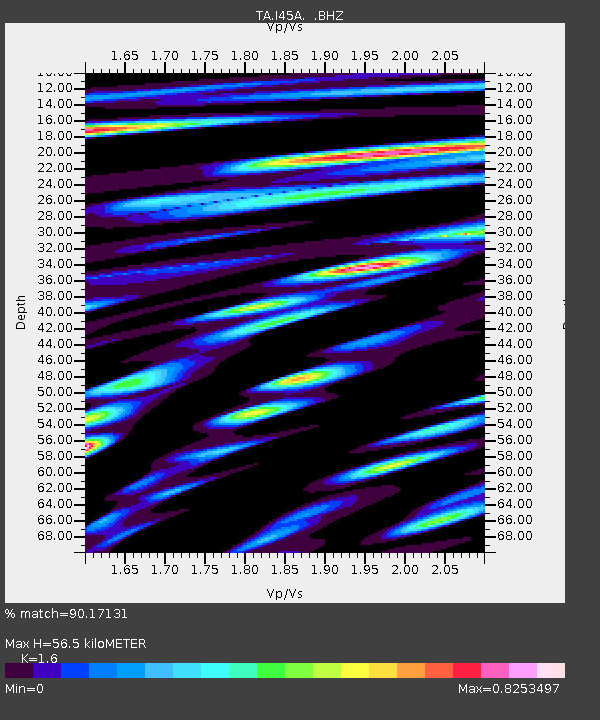
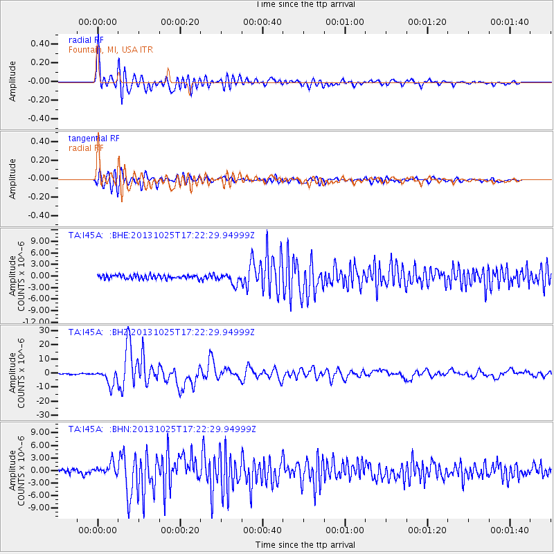
I45A Fountain, MI, USA - Earthquake Result Viewer

Earthquake location: Off East Coast Of Honshu, Japan
Earthquake latitude/longitude: 37.2/144.7
Earthquake time(UTC): 2013/10/25 (298) 17:10:19 GMT
Earthquake Depth: 35 km
Earthquake Magnitude: 7.1 MWW, 7.1 MWW, 7.1 MWB, 7.1 MWC, 7.2 MWC, 7.5 MI
Earthquake Catalog/Contributor: NEIC PDE/NEIC COMCAT
Network: TA USArray Transportable Network (new EarthScope stations)
Station: I45A Fountain, MI, USA
Lat/Lon: 44.04 N/86.23 W
Elevation: 215 m
Distance: 87.0 deg
Az: 34.088 deg
Baz: 321.621 deg
Ray Param: 0.04362863
Estimated Moho Depth: 56.5 km
Estimated Crust Vp/Vs: 1.60
Assumed Crust Vp: 6.53 km/s
Estimated Crust Vs: 4.082 km/s
Estimated Crust Poisson's Ratio: 0.18
Radial Match: 90.17131 %
Radial Bump: 400
Transverse Match: 84.02181 %
Transverse Bump: 400
SOD ConfigId: 626651
Insert Time: 2014-04-19 06:08:20.773 +0000
GWidth: 2.5
Max Bumps: 400
Tol: 0.001

Signal To Noise

ChannelStoNSTALTA
TA:I45A: :BHZ:20131025T17:22:29.94999Z12.9982255.647424E-64.3447653E-7
TA:I45A: :BHN:20131025T17:22:29.94999Z2.20296141.4482938E-66.5743035E-7
TA:I45A: :BHE:20131025T17:22:29.94999Z2.80864951.4107965E-65.023042E-7
Arrivals
Ps5.3 SECOND
PpPs22 SECOND
PsPs/PpSs27 SECOND