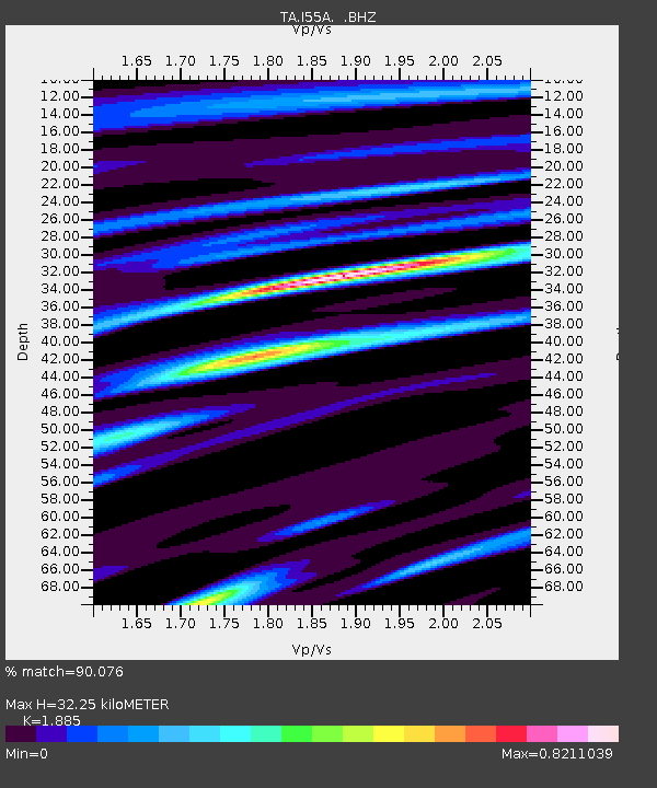
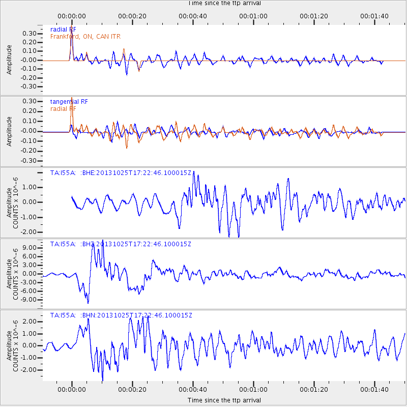
I55A Frankford, ON, CAN - Earthquake Result Viewer

Earthquake location: Off East Coast Of Honshu, Japan
Earthquake latitude/longitude: 37.2/144.7
Earthquake time(UTC): 2013/10/25 (298) 17:10:19 GMT
Earthquake Depth: 35 km
Earthquake Magnitude: 7.1 MWW, 7.1 MWW, 7.1 MWB, 7.1 MWC, 7.2 MWC, 7.5 MI
Earthquake Catalog/Contributor: NEIC PDE/NEIC COMCAT
Network: TA USArray Transportable Network (new EarthScope stations)
Station: I55A Frankford, ON, CAN
Lat/Lon: 44.22 N/77.68 W
Elevation: 132 m
Distance: 90.4 deg
Az: 28.969 deg
Baz: 327.442 deg
Ray Param: 0.04167304
Estimated Moho Depth: 32.25 km
Estimated Crust Vp/Vs: 1.88
Assumed Crust Vp: 6.577 km/s
Estimated Crust Vs: 3.489 km/s
Estimated Crust Poisson's Ratio: 0.30
Radial Match: 90.076 %
Radial Bump: 400
Transverse Match: 74.84823 %
Transverse Bump: 400
SOD ConfigId: 626651
Insert Time: 2014-04-19 06:08:45.046 +0000
GWidth: 2.5
Max Bumps: 400
Tol: 0.001

Signal To Noise

ChannelStoNSTALTA
TA:I55A: :BHZ:20131025T17:22:46.100015Z10.6444533.6614297E-63.4397536E-7
TA:I55A: :BHN:20131025T17:22:46.100015Z3.2721559.652625E-72.949929E-7
TA:I55A: :BHE:20131025T17:22:46.100015Z1.5471735.157924E-73.3337733E-7
Arrivals
Ps4.4 SECOND
PpPs14 SECOND
PsPs/PpSs18 SECOND