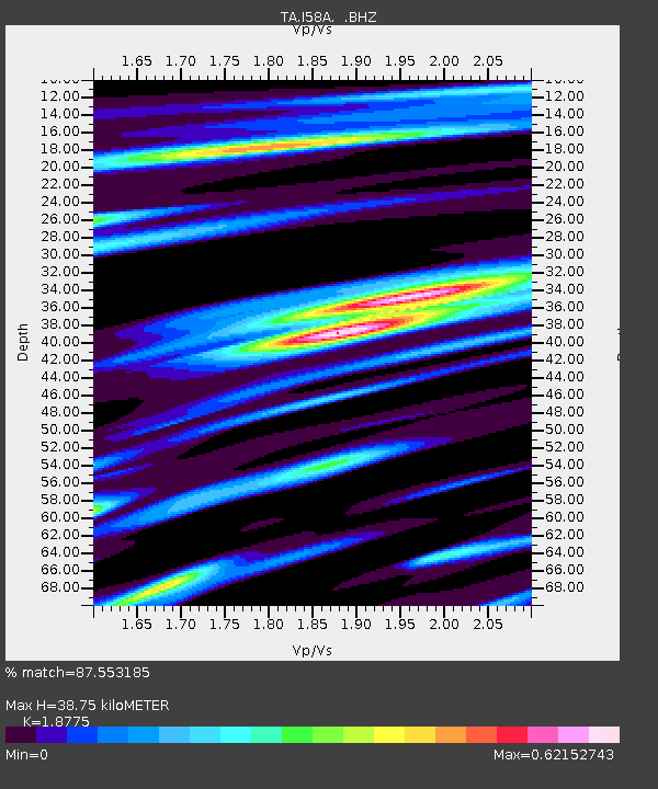
I58A Old Forge, NY, USA - Earthquake Result Viewer
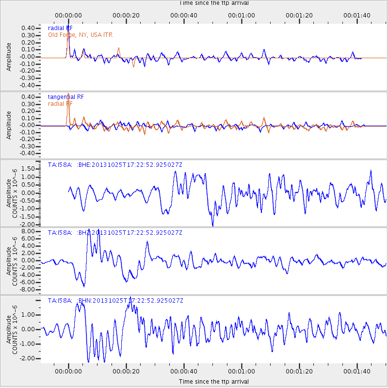
Earthquake location: Off East Coast Of Honshu, Japan
Earthquake latitude/longitude: 37.2/144.7
Earthquake time(UTC): 2013/10/25 (298) 17:10:19 GMT
Earthquake Depth: 35 km
Earthquake Magnitude: 7.1 MWW, 7.1 MWW, 7.1 MWB, 7.1 MWC, 7.2 MWC, 7.5 MI
Earthquake Catalog/Contributor: NEIC PDE/NEIC COMCAT
Network: TA USArray Transportable Network (new EarthScope stations)
Station: I58A Old Forge, NY, USA
Lat/Lon: 43.69 N/74.97 W
Elevation: 599 m
Distance: 91.9 deg
Az: 27.579 deg
Baz: 329.343 deg
Ray Param: 0.041537378
Estimated Moho Depth: 38.75 km
Estimated Crust Vp/Vs: 1.88
Assumed Crust Vp: 6.419 km/s
Estimated Crust Vs: 3.419 km/s
Estimated Crust Poisson's Ratio: 0.30
Radial Match: 87.553185 %
Radial Bump: 400
Transverse Match: 69.45097 %
Transverse Bump: 400
SOD ConfigId: 626651
Insert Time: 2014-04-19 06:08:50.121 +0000
GWidth: 2.5
Max Bumps: 400
Tol: 0.001

Signal To Noise

ChannelStoNSTALTA
TA:I58A: :BHZ:20131025T17:22:52.925027Z9.7172342.997336E-63.084557E-7
TA:I58A: :BHN:20131025T17:22:52.925027Z4.164321.0823204E-62.5990326E-7
TA:I58A: :BHE:20131025T17:22:52.925027Z2.48692518.0422694E-73.2338204E-7
Arrivals
Ps5.4 SECOND
PpPs17 SECOND
PsPs/PpSs22 SECOND