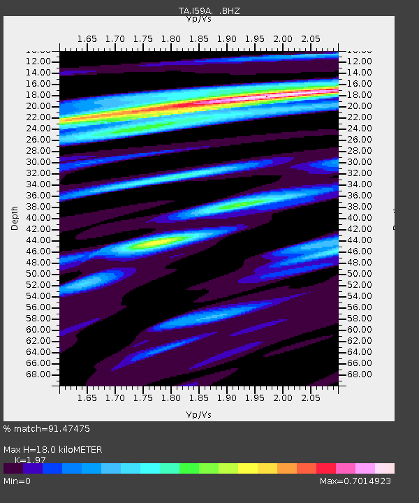
I59A Olmsteadville, NY, USA - Earthquake Result Viewer
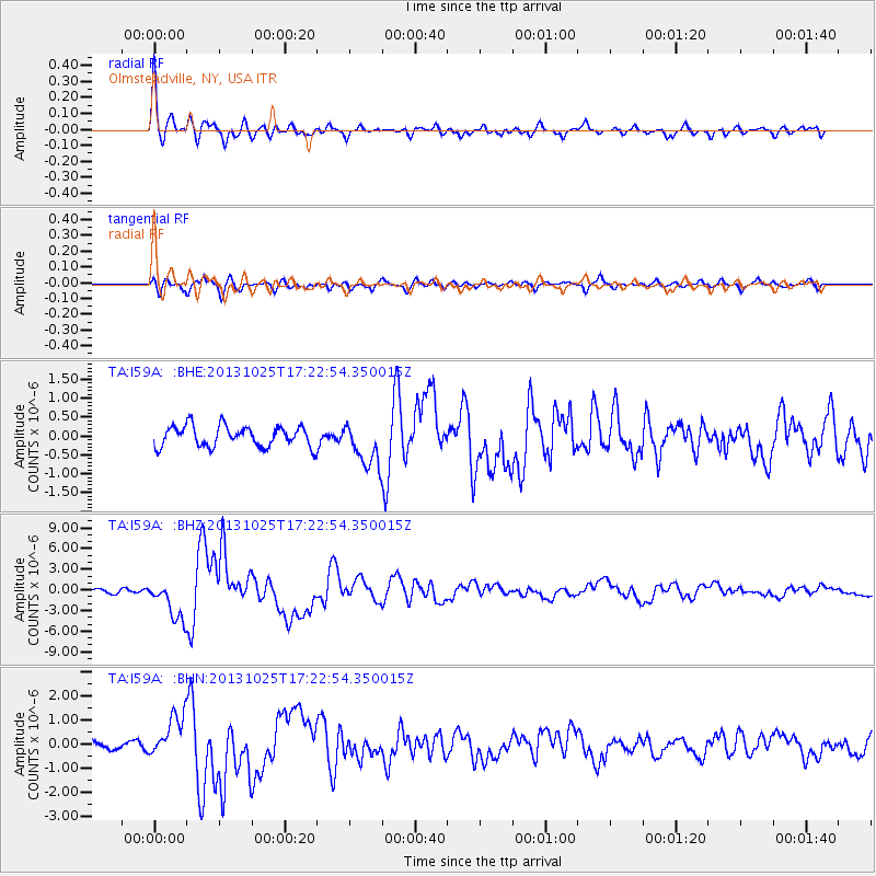
Earthquake location: Off East Coast Of Honshu, Japan
Earthquake latitude/longitude: 37.2/144.7
Earthquake time(UTC): 2013/10/25 (298) 17:10:19 GMT
Earthquake Depth: 35 km
Earthquake Magnitude: 7.1 MWW, 7.1 MWW, 7.1 MWB, 7.1 MWC, 7.2 MWC, 7.5 MI
Earthquake Catalog/Contributor: NEIC PDE/NEIC COMCAT
Network: TA USArray Transportable Network (new EarthScope stations)
Station: I59A Olmsteadville, NY, USA
Lat/Lon: 43.80 N/73.87 W
Elevation: 390 m
Distance: 92.2 deg
Az: 26.837 deg
Baz: 330.126 deg
Ray Param: 0.041490357
Estimated Moho Depth: 18.0 km
Estimated Crust Vp/Vs: 1.97
Assumed Crust Vp: 6.419 km/s
Estimated Crust Vs: 3.258 km/s
Estimated Crust Poisson's Ratio: 0.33
Radial Match: 91.47475 %
Radial Bump: 400
Transverse Match: 64.23032 %
Transverse Bump: 400
SOD ConfigId: 626651
Insert Time: 2014-04-19 06:08:51.329 +0000
GWidth: 2.5
Max Bumps: 400
Tol: 0.001

Signal To Noise

ChannelStoNSTALTA
TA:I59A: :BHZ:20131025T17:22:54.350015Z8.2704542.9030928E-63.5101974E-7
TA:I59A: :BHN:20131025T17:22:54.350015Z3.13980488.944956E-72.8488893E-7
TA:I59A: :BHE:20131025T17:22:54.350015Z2.15233335.8733957E-72.7288505E-7
Arrivals
Ps2.8 SECOND
PpPs8.2 SECOND
PsPs/PpSs11 SECOND