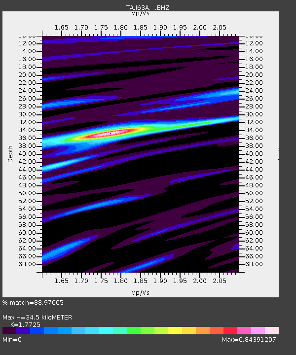
I63A Otisfield, ME, USA - Earthquake Result Viewer

Earthquake location: Off East Coast Of Honshu, Japan
Earthquake latitude/longitude: 37.2/144.7
Earthquake time(UTC): 2013/10/25 (298) 17:10:19 GMT
Earthquake Depth: 35 km
Earthquake Magnitude: 7.1 MWW, 7.1 MWW, 7.1 MWB, 7.1 MWC, 7.2 MWC, 7.5 MI
Earthquake Catalog/Contributor: NEIC PDE/NEIC COMCAT
Network: TA USArray Transportable Network (new EarthScope stations)
Station: I63A Otisfield, ME, USA
Lat/Lon: 44.05 N/70.58 W
Elevation: 177 m
Distance: 93.1 deg
Az: 24.625 deg
Baz: 332.504 deg
Ray Param: 0.041318797
Estimated Moho Depth: 34.5 km
Estimated Crust Vp/Vs: 1.77
Assumed Crust Vp: 6.419 km/s
Estimated Crust Vs: 3.622 km/s
Estimated Crust Poisson's Ratio: 0.27
Radial Match: 88.97005 %
Radial Bump: 400
Transverse Match: 76.427505 %
Transverse Bump: 400
SOD ConfigId: 626651
Insert Time: 2014-04-19 06:09:00.980 +0000
GWidth: 2.5
Max Bumps: 400
Tol: 0.001

Signal To Noise

ChannelStoNSTALTA
TA:I63A: :BHZ:20131025T17:22:58.57499Z5.64829252.9775558E-65.2716035E-7
TA:I63A: :BHN:20131025T17:22:58.57499Z2.9190229.880828E-73.3849787E-7
TA:I63A: :BHE:20131025T17:22:58.57499Z0.80551123.9835183E-74.9453297E-7
Arrivals
Ps4.2 SECOND
PpPs15 SECOND
PsPs/PpSs19 SECOND