You are here: Home > Network List > TA - USArray Transportable Network (new EarthScope stations) Stations List
> Station I64A Boothbay, ME, USA > Earthquake Result Viewer
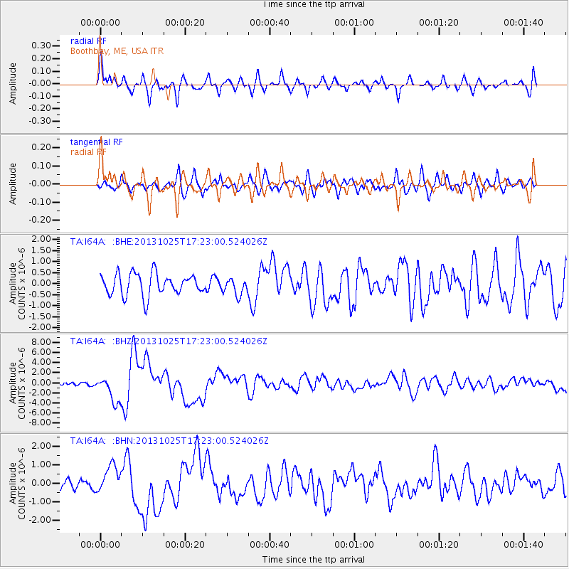
I64A Boothbay, ME, USA - Earthquake Result Viewer
*The percent match for this event was below the threshold and hence no stack was calculated.
| Earthquake location: |
Off East Coast Of Honshu, Japan |
| Earthquake latitude/longitude: |
37.2/144.7 |
| Earthquake time(UTC): |
2013/10/25 (298) 17:10:19 GMT |
| Earthquake Depth: |
35 km |
| Earthquake Magnitude: |
7.1 MWW, 7.1 MWW, 7.1 MWB, 7.1 MWC, 7.2 MWC, 7.5 MI |
| Earthquake Catalog/Contributor: |
NEIC PDE/NEIC COMCAT |
|
| Network: |
TA USArray Transportable Network (new EarthScope stations) |
| Station: |
I64A Boothbay, ME, USA |
| Lat/Lon: |
43.92 N/69.63 W |
| Elevation: |
17 m |
|
| Distance: |
93.5 deg |
| Az: |
24.076 deg |
| Baz: |
333.191 deg |
| Ray Param: |
$rayparam |
*The percent match for this event was below the threshold and hence was not used in the summary stack. |
|
| Radial Match: |
77.261795 % |
| Radial Bump: |
400 |
| Transverse Match: |
60.839893 % |
| Transverse Bump: |
400 |
| SOD ConfigId: |
626651 |
| Insert Time: |
2014-04-19 06:09:06.834 +0000 |
| GWidth: |
2.5 |
| Max Bumps: |
400 |
| Tol: |
0.001 |
|
Signal To Noise
| Channel | StoN | STA | LTA |
| TA:I64A: :BHZ:20131025T17:23:00.524026Z | 4.655313 | 2.65149E-6 | 5.695621E-7 |
| TA:I64A: :BHN:20131025T17:23:00.524026Z | 2.102 | 7.834251E-7 | 3.727046E-7 |
| TA:I64A: :BHE:20131025T17:23:00.524026Z | 0.7850323 | 3.8173062E-7 | 4.8626106E-7 |
| Arrivals |
| Ps | |
| PpPs | |
| PsPs/PpSs | |


